Average outlook continues, with a flukey cyclone swell in the mix
Western Australian Surf Forecast by Craig Brokensha (issued Monday February 19th)
Best Days: Today and tomorrow morning South West magnets, Friday morning
Features of the Forecast (tl;dr)
- Small, mid-period SW swell for this afternoon and tomorrow with E/NE tending N/NE then N/NW winds
- Moderate sized mid-period W/SW swell building Thu PM, peaking early Fri, then easing
- Flukey, inconsistent W/NW cyclone swell building Thu, easing Fri
- Gusty S/SE winds Thu AM ahead of strong sea breezes, fresh E'ly Fri AM ahead of weaker sea breezes
- Small-mod sized, mid-period SW swell for Sun with strong SE tending S/SE winds
- Slightly better mid-period SW swell Tue/Wed with S/SW-SW winds Tue, S/SE-SE Wed AM
Recap
Friday afternoon's kick in S/SW groundswell eased and cleaned up into Saturday with fun 3-4ft sets in the South West, smaller yesterday but fun on the small wave breaks and to 2-3ft.
Perth and Mandurah were clean but tiny.
Today the surf has remained clean but the swell is small and weak, with a new mid-period SW swell now showing across the magnets.

Small new sets this afternoon
This week and weekend (Feb 20 - 25)
Small levels of mid-period swell should continue tomorrow in the 3ft range across the South West magnets with a great E/NE offshore, shifting N/NE and then NW as a trough moves in from the west.
Lingering W/NW winds are likely Wednesday morning, shifting SW and then S/SW as the trough moves east and a high tries to move in. This will be with small, fading surf.
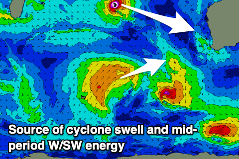
We then look at the mid-period W/SW swell due into the end of the week, generated by a relatively weak polar front projecting up into the Indian Ocean today. The front looks a little weaker and as a consequence the swell looks downgraded a touch and peaking through Friday morning to 4-5ft+ across the South West. Perth and Mandurah should see 1-2ft sets, but there should also be some small W/NW groundswell in the mix from Tropical Cyclone Djoungou.
This tropical cyclone is quite intense but tight, though it's forecast to track south-east, aiming a fetch of severe-gale NW winds off-angle to our swell window.

This is a flukey swell source but we can't rule out a spike in swell to 2-3ft across the metro magnets through Thursday afternoon, easing from a similar size Friday. Any size across the South West will be smaller than the incoming W/SW energy.
Looking at the local winds and a gusty S/SE breeze is due Thursday morning, ahead of the swell with poor S/SW sea breezes into the afternoon, best Friday morning and fresh E'ly across all locations ahead of relative weak sea breezes.
The surf will become smaller on Saturday and another trough looks to bring strong S/SE winds, limiting surfing options.
Into Sunday, a small pulse of new mid-period SW swell is due, generated by weak polar frontal activity through the end of the week, while behind this some stronger activity should generate a moderate sized swell for early-mid next week.
Size wise, the first pulse for Sunday looks to be in the 3-4ft range in the South West, tiny to the north and with strong morning SE winds, with the secondary pulse more to 4-5ft Tuesday/Wednesday. Unfortunately besides Monday (when offshore winds are due), poor S/SW-SW breezes are due Tuesday with S/SE-SE winds possible Wednesday.
We'll have to review this in the next update though as the models diverge a little.
Longer term there's still no major swell generating systems for the region, but more on this Wednesday.

