Large swell tomorrow with workable winds
Western Australian Surf Forecast by Craig Brokensha (issued Wednesday January 24th)
Best Days: Protected spots tomorrow in the South West (morning to the north), Friday morning all locations, Saturday morning on the South West magnets
Features of the Forecast (tl;dr)
- Large SW groundswell for tomorrow with gusty S/SE winds, strengthening into the PM (tending S/SW to the north)
- Easing swell Fri with gusty E/SE-SE winds ahead of strong sea breezes
- Smaller Sat with moderate E winds ahead of sea breezes
- Small pulse of SW groundswell Wed with S/SE tending S/SW winds
- Small-mod sized mid-period SW swell for Mon/Tue with morning SE winds
Recap
The small W'ly swell showed into the late morning Monday across the state, with it hanging in yesterday morning along with some local windswell with semi-clean conditions in Perth and Mandurah. Margs remained onshore and small.
Today the swell has faded with lingering onshore winds in the South West, cleaner to the north but tiny.
This week and weekend (Jan 25 – 28)

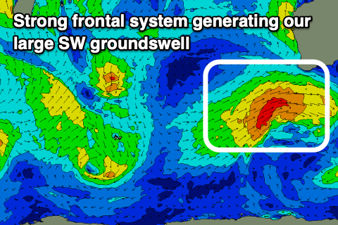
The coming days look much better for surf as a large SW groundswell fills in, generated by a healthy frontal system that's currently passing under the state today.
The frontal system has generated a great fetch of strong to gale-force W/SW-SW winds through our south-western swell window (bottom left), with a large SW groundswell due to fill in tomorrow, reaching 8-10ft across the South West, 3ft in Mandurah and 2-3ft across Perth.
The swell looks to tend more south while easing Friday, backing off from the 6ft range in the South West, 2ft+ in Mandurah and 2ft across Perth. Saturday will be smaller again and best on the South West magnets.
Winds tomorrow will still favour protected spots with a gusty S/SE breeze due, strengthening into the afternoon in the South West and tending S/SW to the north. Friday looks cleaner and better in the South West with a fresh E/SE-SE breeze, moderate and E/SE-SE to the north before strong sea breezes kick back in.

A lighter E'ly offshore will favour those exposed breaks in the South West Saturday as the swell continues to fade.
Into Sunday a fleeting pulse of small W/SW-SW groundswell is due, generated by a burst of W/SW gales around a south-east tracking low forming just north-east of the Heard Island region.
A kick back to the 4ft range is likely through the day across the South West, tiny to the north and with less favourable S/SE tending S/SW winds.
Following this, a weak though broad fetch of strong W/SW winds look to generate a small to moderate sized mid-period SW swell for early next week. Winds look dicey and SE through the morning both Monday and Tuesday with swell in the 4ft+ range across the South West, tiny to the north.
More on this Friday though.

