Poor surf period ahead
Western Australian Surf Forecast by Craig Brokensha (issued Wednesday January 17th)
Best Days: No great days, try protected spots in the South West Friday morning
Features of the Forecast (tl;dr)
- Strengthening W winds tomorrow
- Inconsistent SW groundswell for Fri, peaking during the day with S-S/SE tending strong S/SW-SW winds
- Easing weak swells Sat with S/SE-SE tending strong S/SW-SW winds
- Small W/SW swell building Sun, peaking Mon but with S/SE tending SW winds Sun, fresh W/SW-SW Mon
Recap
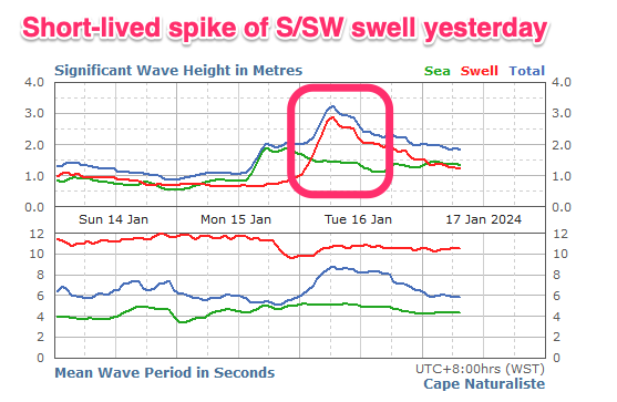
Our tricky pulse of S'ly swell pushing up the coast yesterday came in very nicely but short-lived. The South West south magnets kicked to 4-5ft through the morning before easing during the day with Mandurah kicking to 1-2ft and Perth a similar size but with onshore winds.
Today the swell is all but gone and winds are funky in Perth, clean and offshore to the south with strong breezes and fading swell across the South West.

This week and weekend (Jan 18 – 26)
The low responsible for the hot, humid weather the last couple of days is due to move east, across us tomorrow and this will bring strengthening onshore W'ly winds with no swell.
Friday is looking better but inconsistent as our long-range groundswell fills in during the day.
It might be a little undersized at dawn but to size by mid-late morning and winds are due to swing S'ly but likely still creating bumpy/lumpy conditions. We should see local topography shift winds to the S/SE through the morning ahead of strong sea breezes.
The swell was generated by a strong but tight low to the south-east of South Africa, with inconsistent 4-5ft+ sets due at the peak in the South West, tiny to the north.
Slightly better S/SE-SE winds are due into Saturday morning but the swell will be small and fading, dropping from 3ft or so in the South West on the magnets with tiny windswelly waves to the north.

There's no improvement to the size due on Sunday and similar S/SE winds are due early, shifting S/SW-SW and strengthening from later morning as a mid-latitude moves in and across us (right).
This mid-latitude low will actually bring some weak W/SW swell to the metro beaches through Sunday afternoon/Monday but with the average onshore winds that will persist out of the W/SW-SW, creating average conditions.
No real improvement in the surf or local winds is expected mid-late week thanks to the persistent mid-latitude activity and no strong Southern Ocean storms. More on this Friday.


Comments
When the F**ck are we going to get some swell?