Windy but fun surf over the coming days
Western Australian Surf Forecast by Craig Brokensha (issued Wednesday January 10th)
Best Days: Protected spots today, tomorrow morning protected spots, Friday morning protected spots, Saturday ahead of sea breezes
Features of the Forecast (tl;dr)
- Reinforcing, slightly smaller swell for later today, peaking tomorrow, easing Fri
- Fresh S/SE winds tomorrow, strong into the PM (SW to the north)
- Strong S/SE-SE Fri AM
- Final pulse of less consistent swell filling in Sat, peaking into the PM
- Gusty SE winds, easing and tending E ahead of late sea breezes Sat
- Easing surf Sun with similar winds to Sat
Recap
Yesterday's swell was a little slow to get going in the South West but conditions were average and choppy in any case, with the afternoon providing windswept options out of the wind. Perth and Mandurah saw some low quality windswell with cross-shore winds, building into the afternoon as winds shifted more onshore.
This morning was cleaner and better across all locations with easing surf from 4-5ft in the South West, 1-1.5ft to the north.

Semi-raw though sizey surf still in the mix today
This week and weekend (Jan 12 – 14)
With the first pulse of swell having peaked and now on the ease, there's plenty of reinforcing energy due over the coming days with workable winds across the South West.
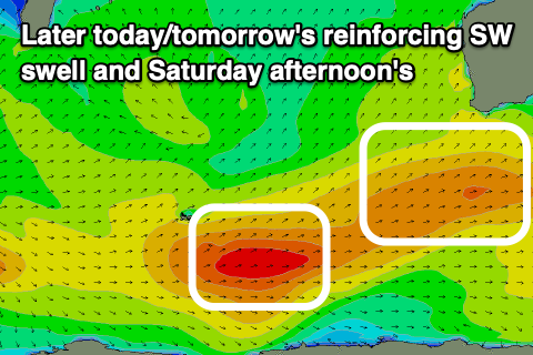
The current and coming energy has been generated by back to back frontal systems moving through our south-western swell window since the weekend.
While not overly strong, they've been persist, with a good pulse of reinforcing energy due to fill in later today, peaking tomorrow, before easing slowly Friday.

One final pulse of SW groundswell is due to move in Saturday, peaking through the afternoon. This swell will be a touch stronger than the current energy but less consistent, generated by a more distant, polar fetch of gales in the Heard Island region yesterday.
Looking at the sizes, and tomorrow's swell should provide 4-5ft+ sets in the South West, 1-1.5ft across Perth and Mandurah, easing slowly through Friday. Saturday's should then build back to an inconsistent 4-5ft on the South West magnets, tiny to the north, easing back through Sunday.
Winds are a little average again tomorrow, fresh from the S/SE in the morning, stronger into the afternoon with strong SW sea breezes to the north. Strong but slightly better S/SE-SE winds are then due on Friday morning with better SE winds on Saturday morning, easing and tending more E through the late morning ahead of S/SE winds into the afternoon.
Similar SE winds are due on Sunday as the size fades, possibly tending more E again through the day but we'll review this on Friday.
It'll be down, down, down into early next week as the Southern Ocean storm track settles down. Conditions will be clean Monday and Tuesday mornings but with no swell. Make the most of the current and coming waves.

