Nothing great but workable waves for the period
Western Australian Surf Forecast by Craig Brokensha (issued Friday January 5th)
Best Days: This morning and tomorrow morning South West magnets, protected spots Sunday morning, Monday morning and Tuesday/Wednesday mornings, Perth and Mandurah Wednesday morning for the keen
Features of the Forecast (tl;dr)
- Small, inconsistent SW groundswell for Sat with mod-fresh E/SE-E winds ahead of strong SW sea breezes
- Moderate sized W/SW swell Sun, peaking during the PM with gusty S/SE-SE tending strong S/SW-SW winds
- Easing swell Mon with moderate S/SE-SE winds ahead of strong S/SW-SW winds
- Moderate sized mid-period SW swell building Tue, peaking later, easing Wed
- Strong S/SE winds Tue, S/SE-SE Wed AM
- Reinforcing SW swell Thu/Fri with mod-fresh SE winds Thu AM, strong S/SE Fri AM
Recap
Yesterday's inconsistent W/SW groundswell came in a little underdone across the state, with the morning being a slow 3-4ft before building to a better 5tt or so, a touch under the expected 4-6ft. Perth and Mandurah didn't offer too much in the way of size and this morning the swell is easing from 4ft in the South West on the sets, tiny to the north.

Great conditions as the swell filled in yesterday
This week and next (Jan 6 - 12)
The current swell will continue to ease into tomorrow morning, with a small, inconsistent SW groundswell due to replace it, generated by a short-lived fetch of tight W/NW gales in our swell window.
This should generate a pulse of size to 3ft to occasionally 4ft across the South West magnets, tiny to the north.
Behind this, a better mid-period W/SW swell should fill in Sunday and peak through the afternoon, generated by a weaker but more drawn out fetch of W/SW winds north of the Heard Island region.
This swell will be inconsistent but should build to 4-6ft across the South West and 1ft to occasionally 2ft in Perth/Mandurah before easing slowly Monday.
Locally, winds will be best tomorrow and moderate to fresh from the E/SE-E, giving into strong S/SW-SW sea breezes. As touched on in Wednesday's update, winds will deteriorate Sunday, becoming fresher from the S/SE-SE in the South West, cleaner to the north ahead of strong sea breezes as the swell peaks. Try protected spots in the morning.

Weaker S/SE-SE winds are due Monday morning as the swell eases from the 4-5ft range in the South West, tiny to the north, with less favourable and strong S/SE winds kicking in from Tuesday. Winds may turn a little S/SE-SE on Wednesday but remain strong, better and SE on Thursday morning.
Swell wise, a couple of fun mid-period swells are due, the first arriving Tuesday and peaking later in the day, with some secondary energy Thursday afternoon/Friday.
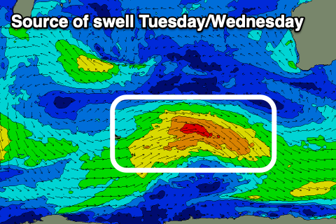
The sources will be weak but healthy frontal activity projecting slowly east-northeast towards us on the weekend and next week.
The first system looks to be the best swell producer, generating a fetch of persistent, strong W/SW winds through our south-western swell window.
A moderate sized mid-period swell is due, building through Tuesday and reaching 5-6ft later, easing from 4-6ft on Wednesday morning. Perth and Mandurah should offer slow 1-2ft sets at the peak of the swell.
The secondary activity looks to maintain smaller, surf into the end of the week more to 3-5ft in the South West but with what looks to be a return to strong S/SE winds. More on this next week, have a great weekend!

