Fun swell tomorrow with another pulse Sunday
Western Australian Forecast by Craig Brokensha (issued Wednesday January 3rd)
Best Days: Tomorrow when winds back off, Friday morning, Saturday morning in the South West for the keen but more so Sunday morning, Monday morning Perth and Mandurah
Features of the Forecast (tl;dr)
- Moderate sized, inconsistent W/SW groundswell filling in tomorrow, peaking in the PM with strong but easing E/SE-E winds and strong S/SE sea breezes (variable to the north)
- Easing swell Fri with similar winds to Thu though weaker and with S/SW-SW sea breezes
- Small, inconsistent SW groundswell for Sat with fresh E/SE-E winds ahead of sea breezes.
- Moderate sized W/SW swell Sun, peaking during the PM with gusty S/SE tending strong S/SW-SW winds
- Weak SW windswell easing Mon with S/SE winds in the South West, variable to the north in the AM
Recap
Our small lift in W/SW groundswell showed best across the metro regions which have otherwise been tiny, increasing to 1-1.5ft through the day and hanging in this morning. Margs increased to a windy 3-4ft but is now easing back from the 3ft range.
This week and weekend (Jan 4 - 7)
Following yesterday’s small bump of swell, we’ve got a better though less consistent swell due tomorrow, with a peak expected through the afternoon.
The source was a good fetch of W’ly gales to the south-east of the Heard Island region and should build to an inconsistent 4-6ft across the South West tomorrow, 1-2ft in Mandurah and 1-1.5ft across Perth.
Conditions look good but windy early with a strong but easing E/SE-E wind, giving into strong S/SE sea breezes. To the north winds look to be favourable all day.
The easing trend will be slowed into Friday with dropping 4ft+ sets across the South West, 1-1.5ft to the north and with slightly weaker but still fresh E/SE-E winds ahead of afternoon sea breezes across all locations.

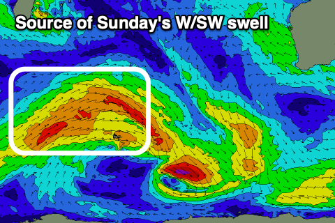
Moving into the weekend, we’ve got a mix of swells due, generated by an elongated frontal surge again to the south-east of South Africa.
At the head of the progression, a brief fetch of W/NW gales are due to produce a small SW groundswell pulse for Saturday morning, but behind this, a drawn out fetch of weakening, strong to near-gale-force W/SW winds will generate some reinforcing mid-period swell for Sunday.
Saturday’s swell only looks to be 3-4ft in the South West, tiny to the north, with Sunday’s coming in at 4-6ft across the South West, with inconsistent 1ft to occasionally 2ft sets to the north.
Conditions should be nice and clean with a moderate to fresh E/SE offshore ahead of afternoon sea breezes on Saturday, but at the peak of the swell Sunday, less favourable S/SE winds are due as an inland trough deepens across the state. This will see onshore S/SW-SW winds kick in through the afternoon kicking up some localised windswell.
This windswell looks to offer 1-2ft surf on Monday morning in Perth and Mandurah with variable winds, S/SE across the South West with easing 4-6ft sets.
The inland low looks to dominate local winds through next week with S/SE breezes due for the most part along with a moderate sized + SW groundswell on the cards for Friday/Saturday. More on this Friday.

