Improving surf today, easing with options next week
Western Australian Forecast by Craig Brokensha (issued Friday December 29th)
Best Days: Today ahead of the wind change in the South West, tomorrow morning in the South West, Tuesday morning protected spots, Thursday morning, Friday morning
Features of the Forecast (tl;dr)
- Inconsistent SW groundswell and mid-period swell peaking this afternoon, easing tomorrow with strong E/SE winds, easing ahead of S/SE sea breezes
- Small reinforcing S/SW swell for tomorrow PM, easing Sun AM with gusty S/SE tending strong S/SW winds
- Smaller Mon with fresh S/SE winds, strong into the PM
- Small-moderate sized W/SW groundswell Tue with fresh S/SE-SE winds, stronger into the PM from the S/SE
- Easing surf Wed with strong S/SE-SE morning winds
- Moderate + sized, inconsistent W/SW groundswell for Thu, peaking into the PM with fresh E/SE tending S/SW winds
- Easing swell Fri with E/SE tending S/SW winds
Recap
Conditions were windy yesterday with a little more swell than we saw on Wednesday, coming in around 4ft in the South West and 1-1.5ft to the north.
Today it’s slower and with strong offshore winds that are making for bumpy conditions across the South West with sets to 4ft+ on the magnets (the swell is filling in stronger with a few 5ft sets showing now), tiny to the north. Conditions will get better through the morning as winds eased before strong S/SE winds kick in.


Crisp off the top and bigger set to follow this morning
This weekend and next week (Dec 30 - Jan 5)
The inconsistent SW groundswell seen across the South West today is mixed in with mid-period energy, with both due to peak this afternoon before easing into the weekend.
The easing trend will be slowed into tomorrow afternoon and Sunday morning thanks to the arrival of a small, reinforcing S/SW, generated by off-axis NW winds currently on the polar shelf, south-west of us.
Good 4ft sets are due to be in the mix tomorrow morning across the South West, with Sunday easing back from 3-4ft. Perth and Mandurah will be tiny.
Conditions will be windy again tomorrow morning with strong E/SE offshore breezes, easing later morning before tending S/SE into the afternoon.
Winds look to go a little south on Sunday as the swell eases, fresh from the S/SE, strong S/SW through the afternoon.
Monday will be smaller with similar, fresh S/SE winds, strong into the afternoon.

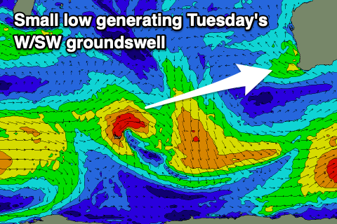
Come Tuesday, a small pulse of W/SW groundswell is due, generated by a small, tight low that’s currently in the Heard Island region. It’ll be short-lived and as a result only a small pulse of energy is due to 4ft across the South West Tuesday, 1-1.5ft to the north.
Winds will remain fresh and mostly S/SE, though likely tending SE for periods in the morning, strong S/SE into the afternoon.
Wednesday will be smaller along with strong SE-E/SE morning winds.
Moving into Thursday, our better, inconsistent W/SW groundswell is due, generated by a more elongated fetch of W’ly gales to the south-east of South Africa Friday and Saturday, easing into Sunday but persisting while pushing east across the Heard Island region.

It’ll be inconsistent but good sized sets to 4-6ft are due across the South West Thursday, peaking through the day with with 1-2ft sets in Mandurah, possibly Perth but most likely 1.5ft.
Conditions should be great with a gusty E/SE offshore ahead of sea breezes, with slowly easing sets through Friday under offshore winds.
Longer term, a slower moving, stronger polar low looks to generate a better groundswell for next Sunday/Monday but we’ll have a closer look at this on Monday. Have a great weekend!

