Smaller surf with fairly workable winds, less so next week
Western Australian Surf Forecast by Craig Brokensha (issued Monday December 18th)
Best Days: Tomorrow morning in the South West and Mandurah, Sunday morning in the South West
Features of the Forecast (tl;dr)
- Easing SW groundswell tomorrow with strong E/SE winds ahead of later sea breezes
- Smaller Wed with similar winds
- Small, mid-period SW swell building Thu PM, peaking Fri AM with SE tending S/SW winds
- Smaller Sat with strong SE tending S/SW winds
- Moderate sized SW groundswell Sun, possibly undersized early (expect waits for sets)
- E/SE tending S/SW winds Sun
Recap
The weekend saw the swell gradually fade away with gusty offshore winds on Saturday, less favourable yesterday. Perth and Mandurah were clean but tiny.
Today, our large, new SW groundswell has filled in under strong offshore winds that are favouring some breaks over others. The South West is 8-10ft on the deepwater reefs, with Mandurah coming in at 2-3ft this morning (undersized early), while Perth has also kicked to 2ft after being tiny early.
The timing of the swell looks to have been a few hours behind but there are options all over right now before sea breezes kick in.

Old mate straightening out on a 10fter
This week and weekend (Dec 19 - 24)
With today's swell currently peaking, we look to the rest of the week and we're due to see windy, clean conditions but with easing swell tomorrow, bottoming out into Wednesday afternoon.
Tomorrow should ease back from 4-5ft across the South West magnets, 2ft on the sets Mandurah and 1-1.5ft across Perth.
A strong but easing E/SE offshore is due tomorrow morning with late sea breezes, smaller Wednesday under similar winds.

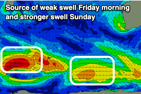
Some small-moderate sized mid-period SW swell is due to build through Thursday afternoon, peaking Friday morning, generated by a relatively weak polar frontal progression that's currently around and east of the Heard Island region.
With fetch strengths below gale-force, only a slight uptick in size is expected, with Friday morning coming in around 3ft to possibly 4ft in the South West, tiny to the north. Morning SE winds will create OK conditions for the desperate.
For the rest of the period we'll be looking at moderate sized, inconsistent pulses of mid-period and groundswell energy from a stream of frontal systems along the polar shelf.
Sunday at this stage looks the biggest, thanks to a burst of gales west of the Heard Island region, with a bit more size to 4-5ft due across the South West (possibly a little undersized early), easing Monday.
Weaker E/SE winds are due on Sunday morning, creating favourable conditions before sea breezes kick in, back to the SE on Monday as it eases.
Winds unfortunately look to swing back to the S/SE-S and persist the rest of next week with the following pulses of swell but we'll review this on Wednesday.

