Slow week, better early next week
Western Australian Surf Forecast by Craig Brokensha (issued Monday December 11th)
Best Days: Protected spots Wednesday morning, next Monday and Tuesday mornings
Features of the Forecast (tl;dr)
- Easing SW groundswell tomorrow, with a small mid-period W/SW swell for the PM, peaking Wed, easing Thu
- E/NE tending W winds tomorrow
- Moderate S/SE tending S/SW winds Wed
- Gusty S/SE-SE winds ahead of strong sea breezes Thu
- Small, easing surf from Fri through the weekend with morning SE winds
- Mod-large SW groundswell arriving late Sun, peaking Mon AM with E/SE tending S/SW winds
Recap
Friday afternoon's pulse of inconsistent SW groundswell started to ease on Saturday with great conditions and fun waves across all coasts. Margaret River and Mandurah were the pick, while yesterday was smaller and only really surfable in the South West.
Today conditions are even smaller with a small background SW groundswell in the South West, tiny to the north.

Small background SW groundswell lines today
This week and weekend (Dec 12 - 17)
Following today's small lift in groundswell, we'll see it easing tomorrow ahead of some weaker but slightly better sized mid-period W/SW energy into the afternoon, peaking Wednesday.
The source was a relatively weak but broad frontal system generating a fetch of sub-gale-force W/SW winds, with a lift to 4ft to occasionally 5ft due across the South West, 1-2ft to the north.
Conditions tomorrow will be clean but the surf small with E/NE offshores ahead of sea breezes, while less favourable but workable S/SE winds are due on Wednesday morning ahead of sea breezes.

Thursday will see a drop in size along with fresh S/SE-SE winds ahead of strong sea breezes.
Winds will shift more SE but remain strong into Friday along with no major surf, just some small, background mid-period SW energy, smaller into the weekend along with morning SE winds.
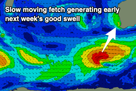
Longer term a fun SW groundswell is on the cards for Monday, generated by a healthy, slow moving frontal system firing up around the Heard Island region on Thursday. A good fetch of strong to gale-force W/SW winds are due, with a moderate-large SW swell resulting, arriving overnight Sunday and peaking Monday to 6ft to occasionally 8ft in the South West, 2ft to occasionally 3ft across Mandurah and 2ft in Perth.
Winds look great at this stage and E/SE on Monday morning but we'll have a closer look and confirm this on Wednesday.

