Slowly easing surf with cleaner conditions
Western Australian Surf Forecast by Craig Brokensha (issued Monday December 4th)
Best Days: Tomorrow morning, Wednesday morning, Saturday morning, Sunday morning in the South West
Features of the Forecast (tl;dr)
- Drop in swell tomorrow, but with a reinforcing SW pulse maintaining wave heights, easing slowly Wed and Thu
- E/SE-SE winds tomorrow AM, with strong sea breezes
- Mod-fresh E/SE-SE winds Wed AM in the South West, S/SE to the north ahead of strong sea breezes
- Strong S/SE winds Thu and Fri
- Moderate sized +, inconsistent SW groundswell for later Fri, peaking early Sat
- Strong SE tending S winds Sat, E tending S/SW winds Sun
Recap
A poor weekend of surf with increasing onshore winds and tiny surf Saturday and early yesterday, building in size through the afternoon.
Today we've got a peak in large W/SW groundswell with average, onshore winds and surf to 8ft in the South West, 3ft across Mandurah and 2-3ft in Perth. This lingering onshore flow isn't ideal but there are better conditions due over the coming days.
This week and next week (Dec 5 - 10)
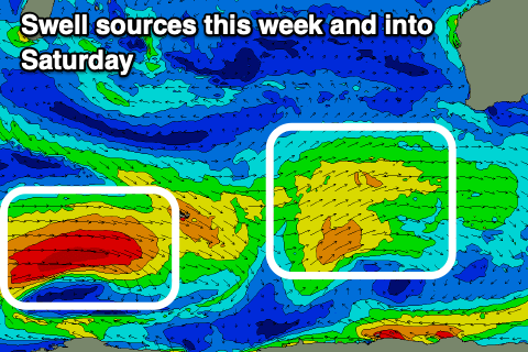
Looking at the week ahead, we've got plenty of swell due with improving conditions with the slow moving low in the southern Indian Ocean, now breaking down, followed by weaker, trailing frontal activity.
This will see the longevity of the swell drawn out, with an initial, moderate to large pulse of reinforcing SW swell due tomorrow, maintaining 6ft+ sets in the South West, 2-3ft across Mandurah and Perth, easing Wednesday from 5ft in the South West, 2ft to the north.
Conditions tomorrow should be nice with an E/SE-SE offshore before sea breezes kick in, strong through the afternoon.

Wednesday morning looks similar wind wise in the South West, moderate to fresh E/SE-SE, while to the north S/SE winds are expected before strong sea breezes kick in.
As the swell starts to become smaller later week, less favourable, strong S/SE winds are due, limiting surfing options so get in over the coming days.
Moving into Friday afternoon and Saturday morning, a new inconsistent SW groundswell is due, generated by a strong low that formed on the polar shelf, south-east of South Africa on the weekend. A good fetch of gales were generated in our far swell window, with the low now weakening.
We should see a fun kick in inconsistent swell though across the South West, peaking Saturday morning to 5-6ft, 2ft Mandurah and 1-2ft across Perth.
Strong SE winds will create workable conditions on Saturday morning, better and E'ly on Sunday but with easing surf. Longer term, small to moderate pulses of swell are likely but we'll have a closer look at this on Wednesday.

