Slight upgrade in next weeks swell with workable winds
Western Australian Surf Forecast by Craig Brokensha (issued Wednesday November 29th)
Best Days: Friday morning South West magnets, Monday morning, Tuesday morning, Wednesday morning in the South West
Features of the Forecast (tl;dr)
- Fading W/SW windswell tomorrow
- Small mid-period SW swell for tomorrow PM, easing Fri
- S/SE tending strong S/SW-SW winds tomorrow
- E/SE-ENE winds Fri AM ahead of sea breezes
- Fading swell Sat with weak W winds, possibly variable early
- Building mix of W/SW swells Sun with strong W/NW tending W/SW winds
- Large W/SW groundswell arriving late Sun, peaking Mon with light W/NW winds in the South West, E/SE-SE to the north, ahead of sea breezes
- Easing W/SW-SW swell Tue with S/SE tending S/SW winds
- Easing moderate sized swell Wed with SE tending S/SW winds
Recap
Poor surf yesterday with weak but freshening onshore winds through the day along with a weak, building windswell.
Today conditions are cleaner with 3ft surf across the South West, 2ft sets in Perth and Mandurah though still quite weak.
This week and next week (Nov 30 – Dec 8)
The current weak swell is due to ease back through tomorrow and winds will shift S/SE as the surface trough/low linked to the current average conditions weakens and breaks down.
Strong afternoon S/SW-SW sea breezes will kick in as a new pulse of small, mid-period SW swell peaks, generated by weak background frontal activity through the Southern Ocean.
This swell should reach 4ft in the South West with fading 1-2ft sets across Perth and Mandurah from the morning, with Friday easing back from 3ft+ across the South West.
Winds look great Friday morning, shifting E/SE-E/NE before sea breezes kick in.
Saturday will be smaller and with weak onshore winds, possibly variable at dawn but with no size.
Moving into Sunday an approaching front linked to a broad, weakening mid-latitude low will bring strong W/NW tending W/SW winds as it moves across us.

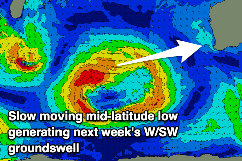
This will bring with it a mix of building windswell and mid-period energy on Sunday, but of greater importance is some stronger W/SW groundswell due later in the day but more so Monday.
The groundswell will be generated by the earlier stages of the mid-latitude low, with it forming south-east of South Africa yesterday. The low looks a touch stronger than forecast on Monday with a fetch of strong to at times, gale-force W/SW winds due to move slowly east towards us, weakening on approach Friday evening and Saturday morning.
This will generate a large W/SW groundswell for Monday morning, coming in at 8ft across the South West, 3ft in Mandurah and 2-3ft across Perth.
Winds look to remain onshore but ease through Monday across the South West, light from the W/NW offering workable options while Perth and Mandurah look offshore ahead of afternoon sea breezes.
We should see a high move in Tuesday following the front on Sunday/Monday, swinging winds around to the S/SE as the W/SW groundswell eases back from the 6ft range in the South West, 2-3ft Mandurah and 2ft Perth.
Winds will shift SE through Wednesday as the swell continues to ease. The easing trend will be slow thanks to a trailing weak fetch of SW winds on the backside of the low.
Longer term the outlook is active and better than it has been, more on this Friday.


Comments
Thanks for the updates Craig, Water Patrol Australia really appreciates the assistance we get from Ben & yourself @ Swellnet. Cheers Perry
Our pleasure Perry.
All I can say is hallelujah! .. at last some waves!