Small swells with strong winds
Western Australian Surf Forecast by Craig Brokensha (issued Friday November 17th)
Best Days: Later tomorrow morning on the South West magnets, and Tuesday morning similar spots
Features of the Forecast (tl;dr)
- Small mid-period S/SW swell building tomorrow, with a secondary reinforcing S/SW groundswell Sun AM, easing
- Fresh E/SE-E tending strong S winds tomorrow
- Stong S/SE_SE tending S winds Sun
- Small inconsistent mid-period SW swell building Mon, easing Tue and small Wed
- Strong SE tending S winds Mon, E/SE-SE Tue and Wed AM
Recap
Small, fading surf across the South West with clean though gusty conditions yesterday morning, smoother today but very small. Perth and Mandurah have been tiny.
This weekend and next week (Nov 18 - 24)
The coming forecast period remains unfavourable swell wise, with strong and persistent SE winds.
A strong high sitting under us is blocking any major storms firing up in the Southern Ocean, while a heat low to the north squeezes the top side of the high, generating persistent strong winds from the south to south-east.
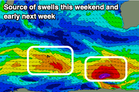
Polar storms skirting around the bottom flank of the high and firing up towards Tasmania will generate small pulse of background S/SW swell energy on the weekend and early next week but with no major size.

The pulse on the weekend was generated by a significant 'bombing' low forming late in our swell window, too late to generate any real size unfortunately. We're still expected to see some side-band S/SW swell energy arriving through tomorrow, with a small reinforcing S/SW groundswell for Sunday morning.
Perth and Mandurah aren't expected to get above 0.5-1ft but Margs should build to 4ft on the south swell magnets, easing from a similar size on Sunday morning.
Winds will be favourable tomorrow morning as the swell builds with a fresh E/SE-E breeze, giving into afternoon sea breezes as the swell kicks, while Sunday looks to see less favourable, strong S/SE-SE morning winds tending S into the afternoon.
A temporary low point in swell is due Monday as winds remain strong from the SE, tending S into the afternoon.
Swell wise, a new pulse of mid-period SW swell from the trailing front behind the low is due.
It looks small again and to an inconsistent 4ft into the afternoon across the South West, tiny to the north, easing slowly Tuesday and holding a weak 2-3ft on Wednesday.
The rest of the week will become small to tiny thanks to the lack of any major swell generating storms.
Winds will remain strong and tend SE-E/SE on Tuesday and Wednesday mornings, more E'ly Thursday and E/NE Friday as the high starts moving east.
When does the pattern look to break? There's no major signal as of yet but check back here on Monday for any update. Have a great weekend!

