Fun weekend of easing surf
Western Australian Surf Forecast by Craig Brokensha (issued Friday November 10th)
Best Days: Today protected spots, tomorrow morning, Sunday morning Margs, Monday through Wednesday morning Margs
Features of the Forecast (tl;dr)
- Mod-large SW swell building today, easing slowly tomorrow with strong E/SE winds, easing and tending SE, then strong S/SE in the South West into the PM, S/SW to the north
- Small, fading swell Sun with strong E/SE-SE winds, S/SE into the PM (SE to the north)
- Small-mod sized S/SW groundswell for Mon PM with strong E/SE-SE tending S/SE winds
- Reinforcing small-mod sized S/SW groundswell for Tue PM and Wed AM with strong E/SE-SE tending S/SE winds
- Easing surf Thu with strong E/SE tending S/SE winds
Recap
A weak windswell offered a just-surfable wave across metro locations yesterday morning, poor and onshore across the South West.
Today we've got a building SW swell that's best in protected spots in the South West, coming in at 4-5ft early (now 6ft) while Perth and Mandurah are seeing fun 1-2ft sets. More size is due through the day, peaking into the afternoon at 6-8ft as winds strengthen and tend S-S/SW, (S/SW to the north). Mandurah should reach 2ft to occasionally 3ft with 2ft+ sets in Perth.

Size starting to show
This weekend and next week (Nov 11 - 17)
This afternoon's increase in swell will start to back off through tomorrow but we're still expecting to see 6ft+ sets across the magnets in the South West, 2ft+ across Mandurah and 2ft in Perth, easing into the afternoon and more noticeably from 3-4ft in the South West Sunday morning, tiny to the north.
The longevity of the swell is thanks to the slow moving nature of the low that generated it.
Winds look great tomorrow and strong offshore from the E/SE during the morning, easing and tending SE late morning ahead of strong S/SE sea breezes in the South West, S/SW to the north.
Strong E/SE-SE winds are again expected on Sunday but with the fading swell, with sea breezes suppressed to the north, S/SE in the South West.

Into next week, we'll see persistent, strong E/SE-SE morning winds ahead of sea breezy afternoon's as a strong high sits south of us, remaining there until late week, when it'll slowly shift east.
A deepening heat low to our north will squeeze the high, bringing these winds, clocking more E/SE late week as the high starts mobilising east.
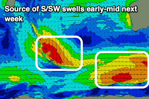
Swell wise, small to moderate sized pulses of S/SW groundswell are due to spread up radially off polar fronts skirting around the bottom flank of the high. The first is due Monday afternoon, boosting the South West magnets to 4ft, easing Tuesday ahead of a secondary similar sized pulse later Tuesday, easing Wednesday.
There might be the stray bigger one on the magnets and the mornings will be best, though windy. Perth and Mandurah won't see any major size to the southerly and small nature of the swells.
Make the most of these background pulses before things settle into the end of the week.
Longer term there's nothing major on the cards thanks to the blocking effect of the high under the state. More on this Monday. Have a great weekend!

