Weak swells for the coming week, possible better swell later next week
Western Australian Surf Forecast by Craig Brokensha (issued Wednesday November 1st)
Best Days: No great days, though try Sunday ahead of sea breezes and Monday morning
Features of the Forecast (tl;dr)
- Small early tomorrow with gusty SE tending strong S/SE winds
- Small background SW swell arriving tomorrow PM, easing Fri with strong but easing E/SE winds ahead of sea breezes
- Small pulse of background swell for Sat with mod E/NE winds ahead of sea breezes
- Small-moderate sized mid-period SW swell filling in Sun (peaking in PM) with mod-fresh E-E/NE winds, tending NW ahead of late sea breezes
- Easing surf Mon with E/SE-SE tending S/SW winds
- Small building surf Tue with strong S/SW tending S winds
- Easing swell Wed with gusty S/SE winds
- Smaller Thu with strong S/SW-S winds
- New moderate + sized SW swell for Fri with gusty S/SE winds
- Slowly easing swell next weekend with gusty SE winds Sat AM, E/SE Sun AM
Recap
Monday afternoon offered a good pulse of S/SW swell energy that held in nicely yesterday morning to 4-6ft on the South West magnets with strong offshore winds. Mandurah offered slow 1-2ft sets with tiny waves across Perth.
This morning the swell is smaller and fading from 4ft across the South West magnets with favourable conditions that were a bit blowy early, tiny to the north.

Good conditions yesterday morning with an easing swell
This week and next (Nov 1 - 10)
The swell will bottom out into tomorrow morning ahead of a new pulse of mid-period swell through the day, generated by a weak polar front moving through our swell window earlier this week.
A slight pulse to 3ft may be seen in the South West through the day but with gusty SE winds, strengthening from the S/SE during the afternoon. Perth and Mandurah look to remain tiny.
Friday looks cleaner but smaller with 2-3ft sets left on the magnets under strong but easing E/SE winds ahead of mid-afternoon sea breezes.
Saturday will be clean again in the morning along with moderate to fresh E-E/NE winds and mid-afternoon afternoon sea breezes, while a small lift in background swell should maintain 3ft sets in the South West.
Our slightly stronger pulse of swell for Sunday is on track, generated by a slightly stronger but more distant polar front that formed west of the Heard Island region on Monday.
It'll be inconsistent but better sets to 3-5ft are due in the South West (peaking into the afternoon) as Perth and Mandurah remain tiny.
Moderate E/NE winds should create clean conditions ahead of weak NW sea breezes, stronger into the evening when reverting back to the S'th.
Monday looks to then see easing surf along with E/SE-SE winds, shifting S/SW as a trough moves in from the west. Unfavourable S-S/SW winds are due Tuesday along with a slight lift in swell but nothing of real note.
This swell is being generated by another distant, weak, polar frontal system and should build Tuesday afternoon, reaching 4ft across the South West, easing from a similar size on Wednesday as winds shift S/SE in the morning. Perth and Mandurah will remain tiny.

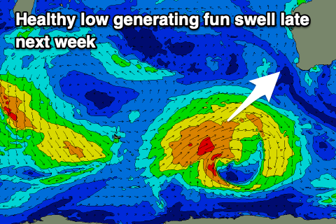
Winds look to deteriorate again Thursday as a swell generating front clips us, bringing strong S/SW winds that will then shift S through the day. S/SE winds look to kick in on Friday along with a moderate sized pulse of new mid-period swell from the aforementioned swell generating storm, that being a weak but slow moving polar low firing up to our south-west early-mid week.
At this stage the winds inside the low look to be mainly below gale-force in strength, with a fun pulse to 5-6ft due across the South West, 1-2ft in Mandurah and Perth but with those S/SE winds.
The weekend should see a slow drop in size as winds shift SE on Saturday and then E/SE Sunday morning but we'll confirm this Friday.

