Poor run for most locations, improving to the north mid-week
Western Australian Surf Forecast by Craig Brokensha (issued Friday September 1st)
Best Days: Wednesday morning Perth and Mandurah, Thursday morning Perth and Mandurah, Friday morning, Saturday morning next week
Features of the Forecast (tl;dr)
- Strengthening W/NW winds Sat
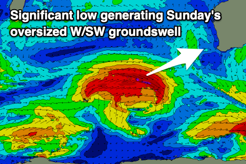
- Oversized W/SW groundswell for Sun with strong W/SW-SW winds
- Oversized, stormy SW swell Mon AM, easing with strong, easing W/SW winds, fading further Tue with strengthening W/NW winds
- Large, mid-period W/SW swell Wed with moderate SW tending W winds in the South West, light S/SE-SE to the north in the AM
- Easing surf Thu with W winds in the South West, E/NE in the AM to the north
- Gusty S/SE-SE winds Fri with smaller, easing surf
- Possibly large S/SW groundswell next weekend with offshore winds
Recap
The South West offered great surf yesterday with clean conditions and a building swell to the 6ft range through the day, tiny to the north with some fun sets seen into the afternoon.
Today an onshore change has spoilt conditions across the South West with a window of cleaner waves in Perth and Mandurah to 1-2ft with foggy conditions across the former.

Great, building surf yesterday
This weekend and next week (Sep 2 - 8)
Onshore, that's the short of it unfortunately for the South West with a return to winter conditions with oversized, stormy surf due to develop on the weekend.
Windows to the north look limited as well but this outlined below.

Currently, a strong frontal system is generating a great fetch of gale to near severe-gale W/SW winds just north-east of the Heard Island region, with it due to project towards us while weakening this evening and tomorrow.
As the front approaches we'll see strengthening W/NW-NW winds tomorrow, while the large W/SW groundswell is due to fill in Sunday and push to 10-12ft across the South West, build to 4ft in Mandurah and 3-4ft across Perth with some local windswell in the mix.
Strong W/SW-SW winds will create poor conditions on Sunday while a secondary front pushing up and into us through the day and evening will generate a boost in size for Monday morning to the stormy 12ft range across the South West, holding 4ft in Mandurah and 3ft+ across Perth.
There'll be little respite before the next fronts moves in with strong but easing W/SW winds.

Strengthening W/NW winds will be seen on Tuesday as the swell continues to ease, while some large sized, mid-period W/SW swell is due Wednesday from this relatively weak front moving through.
Sets to 8ft are due in the South West, 3ft Mandurah and 2-3ft in Perth as winds finally improve.
We should see weaker SW winds across the South West, tending W'ly during the day, S/SE-SE in Mandurah and Perth through the morning ahead of weak sea breezes.
Thursday also looks clean in Perth and Mandurah but smaller, lingering onshore from the W across Margs.
Looking at next weekend, E/SE-SE winds look to develop with a possible large, new S/SW groundswell but we'll have a closer look at this on Monday. Have a great weekend!

