Large kick in windy surf tomorrow, improving slowly while easing Friday

Western Australia Surf Forecast by Craig Brokensha (issued Wednesday July 12th)
Best Days: Perth and Mandurah Friday morning, protected spots in the South West through the day, all locations Saturday (Margs in the AM), Perth and Mandurah Sunday and Monday mornings
Features of the Forecast (tl;dr)
- Large mix of W/SW groundswell and mid-period SW swell tomorrow, easing slowly Fri and further Sat
- Strong W/NW tending SW winds tomorrow
- Strong S/SW but easing S winds Fri (fresh S/SE tending S/SW to the north)
- Moderate E/NE tending variable winds Sat to the north (E/NE-NE tending N/NW and strengthening in the South West)
- Smaller Sun with gusty N/NW-NW winds in the South West, NE in the AM to the north
- Large building W/SW groundswell Mon with gusty N/NW-NW winds in the South West, NE in the AM to the north
- Larger swell Wed with strong S/SW-SW winds
Recap
Building surf through yesterday which hit the XL size range into the afternoon across the South West but with generally poor conditions, average to the north with a slim window of lighter winds around Perth.
Today the swell is on the ease as conditions remain poor across most spots, lumpy and a bit better around Perth with 2-3ft sets.
This week and next (Jul 13 - 21)
A strong mid-latitude frontal system will clip us this evening, bringing more onshore winds to all locations tomorrow and a large mix of W/SW groundswell followed by mid-period SW swell.
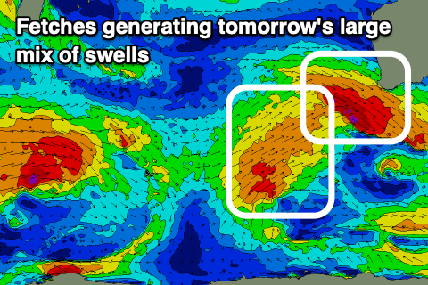
Gale-force W/NW winds will be followed by strong W/SW winds and this should kick the size back to 10-12ft across the South West, 3-4ft in Mandurah and 2-3ft across Perth but with strong W/NW tending SW winds as the front moves through.
There's a possible window of lighter S'ly winds in between the change for Perth and Mandurah, but Friday is a much better chance for cleaner conditions.
The swell looks to be easing back from the 10ft range in the South West Friday morning, 3ft Mandurah and 2-3ft across Perth with moderate to fresh S/SE tending S/SW winds in northern locations.
Protected spots in the South West should improve with a strong but easing S/SW tending S'ly breeze.
There'll be a short window of decent conditions Saturday as the swell fades further, easing from 6-8ft on the South West magnets and 2ft+ across Mandurah (2ft Perth) and morning E/NE-NE winds will freshen and then tend N/NW into the afternoon while strengthening. Perth and Mandurah should see E/NE tending variable winds offering decent conditions all day.
Sunday looks smaller and winds will remain gusty from the N/NW-NW across the South West (NE early to the north but small).

A strong frontal progression moving in from South Africa today, bringing the strengthening NW winds will also bring with it a large new W/SW groundswell for Monday.
Winds look to play out similar to Sunday, best in the north and we should see the South West building to 8-10ft, 2-3ft across Mandurah and 2ft+ in Perth.
Following this, a high riding, strengthening low will push right up and into us Wednesday, bringing with it an oversized swell and onshore winds. We may see this system clear quite quickly into the end of the week, bringing a temporary improvement in local winds but we'll have a closer look at this Friday.