XXL swell for the coming days
Western Australia Surf Forecast by Craig Brokensha (issued Monday July 3rd)
Best Days: Perth this afternoon, Perth and Mandurah Thursday morning, Perth and Mandurah Saturday morning
Features of the Forecast (tl;dr)
- XXL SW swell for tomorrow, peaking into the afternoon, easing slowly Wed
- Strong W/SW winds tomorrow, SW Wednesday
- Smaller Thu but still large in the South West with strengthening W/SW winds, lighter and E/NE to the north in the AM
- Building mid-period SW swell Fri with strengthening W/SW winds
- Peak in SW swell Sat with SW winds in the South West, variable to the north
- Mod-large SW groundswell Sun with increasing N/NW winds
Recap
An early window of clean, small 2ft waves Saturday in the South West, tiny elsewhere, poor yesterday with choppy conditions.
Today we've got a mix of building NW windswell and large W/SW groundswell with workable conditions for the keen and experienced across Perth this afternoon.

Chunky north sets this afternoon
This week and weekend (Jul 4 - 9)
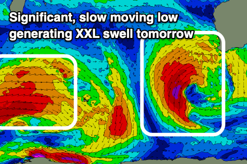
Currently, a severe low is sitting south-west of us, generating a slow moving fetch of gale to severe-gale SW winds through our south-western swell window.

The fetch will slowly move up and into us tomorrow, generating an XXL swell event for tomorrow that now looks to come in at a huge 20ft through the afternoon in the South West 4-6ft across Perth and 4-5ft in Mandurah.
Conditions will be a mess with strong W/SW winds due across all locations tomorrow, SW on Wednesday thanks to the slow moving nature of the low.
It looks like the swell will still be very large and easing from 15ft+ on Wednesday morning, 4-5ft in the South West and 4ft across Perth, smaller Thursday ahead of the next episode of large windy swell building Friday.
Winds will remain onshore Thursday and be moderate to fresh from the W/SW, strengthening through the day, with Perth and Mandurah offering morning E/NE winds.
The swell should still be 3ft in Mandurah and 2-3ft across Perth, well worth a surf.
Looking at Friday and an initial strengthening mid-latitude front should bring some building mid-period SW swell that looks to peak Saturday ahead of some stronger groundswell on Sunday.
Conditions will be poor across all locations Friday with strengthening W/SW breezes, weaker Saturday but likely lingering onshore across the South West, cleaner to the north.
The swell will be on the smaller side to the north on Saturday but fun with 2-3ft sets across Mandurah and small 2ft waves in Perth.
More approaching frontal activity looks to tip winds to the NW on Sunday with larger groundswell pulses due through next week. More on this Wednesday.


Comments
Hi Craig, thanks for the awesome forecasts each week.. did you mean “ It looks like the swell will still be very large and easing from 15ft+ in the South West on Wednesday morning, 4-5ft in Mandurah, and 4ft across Perth, “ ?
Do you think Perth & Mandurah could get variable winds early Wednesday?
Not this time, likely still under the onshore flow.
where is the groundswell it's either been calm and flat or big and onshore
Hi Craig,
I’m having some issues accessing my Swellnet pro account benefits. I’ve updated my payment details the payment has gone and is reflected in my Swellnet account details and in my bank account online statement yet I still can’t access WAMS , 16 day forecast or any Swellnet pro benefits?
I look forward to your response
Sorry mate, gremlin in the system. All sorted now. Thanks for your ongoing support!
All good Ben, thanks for sorting it out!
I thought I was doing something wrong at my end due to my lack IT skills.
I’m lost without my Swellnet mate!! : )
A bit wild and squally on metro coast yesterday arvo, cleared skies and messier today. Certain spots DS will be cranking.
You can watch Pt Moore being washed away, live, here :(
https://www.transport.wa.gov.au/imarine/geraldton-cam.asp