Poor weekend, large and onshore early next week

Western Australia Surf Forecast by Craig Brokensha (issued Friday June 30th)
Best Days: Perth and Mandurah Wednesday morning, keen surfers in the South West selected spots Wednesday morning, Perth and Mandurah Thursday morning
Features of the Forecast (tl;dr)
- Poor, windy weekend
- Large W/SW groundswell building rapidly Monday with strong W/NW tending W winds
- Oversized SW-S/SW groundswell building Tue with strong W/SW tending SW winds
- Easing S/SW groundswell Wed with gusty but easing S/SW winds (light offshore Perth and Mandurah)
- Smaller Thu with W winds in the South West, E/NE to the north early
Recap
Wednesday's inconsistent W/SW groundswell pushed nicely into the afternoon before easing slowly through yesterday. Perth and Mandurah were still in the 1.5ft range under offshore winds, clean and easing from 4ft in the South West.
Today the surf is smaller as winds shift more to the north-east.
This weekend and next week (Jul 1 - 7)
The coming weekend won't be one for surf as the swell bottoms out and winds strengthen from the north ahead of a strong mid-latitude frontal progression moving in from the west.
Tomorrow will see strong NE-N/NE tending N winds with stronger N tending N/NW winds on Sunday with some building, low quality windswell.
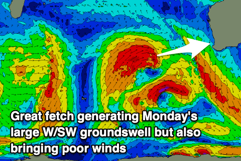
We'll see wind shift strong W/NW and then W on Monday as the first front moves through, followed by a secondary system Tuesday.
These fronts will be quite strong in nature with back to back fetches of gale-force W/SW winds projecting east towards us, nearly reaching severe-gale in strength at stages.
On the backside of the progression a fetch of gale to severe-gale SW winds will continue to prolong the swell event, with it peaking Tuesday, easing slowly Wednesday.
At this stage Monday looks to build rapidly to 10-12ft in the South West as the first pulse of large W/SW groundswell arrives, 4-5ft in Mandurah and 4ft on the sets across Perth.
Larger surf is then due on Tuesday, peaking through the afternoon to what looks to be at least 12-15ft in the South West, holding 4-5ft across Mandurah and 3-4ft in Perth owing to the shift in direction more to the S/SW.
Winds will remain poor though with strong W/SW tending SW winds and no window of lighter winds to the north. Wednesday looks better though with light offshore E/SE winds due to develop across Perth and Mandurah along with solid, easing sets from 3ft and 4ft respectively.
The South West will remain average but protected spots should provide some options with a gusty but easing S/SW breeze. The surf looks to ease back from 12+.
Unfortunately the next bout of weaker frontal activity is due to move in Wednesday, bringing W'ly winds to the South West and no real chance to get a clean wave with the early week swell event.

Perth and Mandurah should offer decent morning conditions but smaller surf.
Now, this frontal stuff will be the remnants of a stronger progression of storms from under South Africa, kicking off this weekend.
Distant fetches of gale to severe-gale W/SW winds will slowly move east, generating a large but inconsistent W/SW groundswell for next weekend.
There's likely to be some closer-range swell energy in the mix when this swell arrives, bringing onshore winds though size wise, we're looking at surf to at least in the 10ft range across the South West but with onshore winds. More on this in Monday's update. Have a great weekend!