Next dose of large, windy swell incoming
Western Australia Surf Forecast by Craig Brokensha (issued Wednesday June 21st)
Best Days: Keen surfers Perth and Mandurah tomorrow morning, Perth and Mandurah Saturday morning, all locations Sunday morning, South West magnets Monday through Wednesday
Features of the Forecast (tl;dr)
- Temp low point in swell tomorrow with strong WSW tending SW winds, variable early Perth and Mandurah
- Oversized S/SW swell building Fri PM with strong SW-S/SW winds, easing Sat with strong S/SW winds (variable offshore early Perth and Mandurah)
- Easing swell Sun with E/SE tending SW winds
- Small Mon with E tending variable winds
- Inconsistent W/SW groundswell for Tue/Wed with morning offshores
Recap
Perth and Mandurah offered windows of lighter winds through yesterday which was a little unexpected along with a peaky mix of swells to 2ft. This morning's conditions were expected though with a peak in mid-period energy to 3ft in Mandurah and 2-3ft across Perth, while the South West has remained poor.
This week and weekend (Jun 20 - 25)
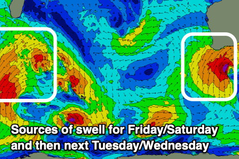
Looking at the end of the week and we'll see a strong polar front, come stalling mid-latitude low directing fetches of strong to gale-force SW tending S/SW winds up into us tomorrow and Friday, bringing a mix of building stormy surf that will peak Friday evening, then ease off into Saturday.
Tomorrow will see strong W/SW tending SW winds as the polar front approaches, with a window of variable winds to the north along with a mix of swells to 2ft to occasionally 3ft.
All locations look to succumb to strong SW-S/SW winds on Friday as the swell builds towards a stormy 12ft+ into the afternoon across the South West, 4ft in Mandurah and 3ft+ across Perth.

Unfortunately a front pushing up on the tail of the mid-latitude low as it moves east will bring strong S/SW winds to the South West on Saturday morning as the swell starts to ease back from a similar size to Friday evening.
Perth and Mandurah should see lighter, more variable winds through the morning creating decent conditions, cleaner across all locations on Sunday with E'ly offshore winds but a weaker easing swell.
The South West should ease back from a lumpy 8ft on the sets early, back to 5-6ft through the afternoon while Perth and Mandurah look to ease from 2ft.
We'll see clean conditions but fading surf into early next week, with a couple of pulses of inconsistent, long-range W/SW groundswell due to arrive through Tuesday/Wednesday.
These will be generated by a strong but distant frontal progression that's currently pushing under South Africa. Once it hits our shores it'll be much smaller and likely in the 4ft range across the South West, tiny to the north.
We'll have a closer look at this on Friday.

