Improving weekend with easing surf
Western Australia Surf Forecast by Craig Brokensha (issued Friday June 16th)
Best Days: Tomorrow all locations (from mid-late AM Mags), all locations Sunday, Perth and Mandurah Wednesday, Thursday and Friday mornings
Features of the Forecast (tl;dr)
- Large easing mix of S/SW swells tomorrow with moderate S/SE tending variable winds in the South West, light E/NE tending variable to the north
- Further drop in swell Sun with E/SE tending variable winds in the South West, E/NE to the north
- Large, building mid-period SW swell Tue with strong SW winds, easing Wed with strong S/SW winds (S/SE to the north)
- Smaller Thu AM with E/SE winds to the north, S/SW to the south
Recap
Poor surf with strong onshore winds and building surf through yesterday, peaking today to 12fft+ in the South West and 3-4ft in Perth and Mandurah but with no improvement in conditions.
This weekend and next week (Jun 17 - 23)
Looking at the weekend ahead, and the large windy surf seen the last two days will finally start to clean up and improve across all locations as we fall in between frontal systems.
The slow moving Southern Ocean gyre linked to the the current run of large, stormy swell will push east this evening, allowing winds to improve, tending S/SE across the South West (possibly still S'ly at dawn), with great E/NE offshore winds to the north.
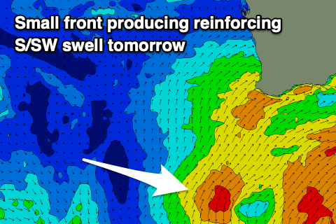
Variable winds are due into the afternoon across all locations and this will see the South West improving all day with decreasing lump and randomness, while size wise we should see the current swell easing back from the 10ft range. A reinforcing mid-period S/SW swell from a fetch of strong S/SW winds projecting north and into us today with slow this easing trend a touch.

Perth and Mandurah look to ease back from 2-3ft and 3ft respectively, smaller Sunday and with light E/SE offshores in the South West, variable into the afternoon, E/NE to the north.
The window of lighter winds and benign weather will only be short-lived with the next strong and persistent progression of frontal systems due to move in early next week.
With this will see strengthening onshore winds and building surf again through Tuesday, easing Wednesday ahead of another phase of swell and fronts later in the week and next weekend.
Looking at the broader scale synoptics and we'll be at the end of a wave train that is seeing strong storms projecting up past South Africa before dipping south-east under the Indian Ocean and then back up towards us.
The South West will lose out in this scenario with better windows to the north in Perth and Mandurah expected Wednesday, Thursday and possibly Friday mornings but we'll have a closer look at this and the sizes on Monday. At this stage the swells look to be in the moderate to large range. Have a great weekend!


Comments
Thanks Craig, for the layman... whats a gyre?
A large area of rotation.
In this case a broad area of low pressure with multiple, smaller lows spinning within it.
As big and as wild as i've seen it in a while today. Impressive stuff.