Another poor week for the South West
Western Australia Surf Forecast by Craig Brokensha (issued Monday June 12th)
Best Days: Perth and Mandurah early tomorrow for the keen, Saturday morning Perth and Mandurah, Sunday morning in the South West
Features of the Forecast (tl;dr)
- Drop in swell tomorrow with strengthening W/NW winds, NE early to the north
- Weak windswell easing Wed with SW tending W winds (possible variable to the north early)
- Large SW groundswell building Thu with strong W winds, becoming XL from the S/SW Fri with strong W tending SW winds
- Easing mod-large swell Sat with gusty but easing S/SW tending S winds in the South West (S/SE-SE in the AM to the north)
- Smaller Sun with E/NE tending variable winds
Recap
Poor surf across the South West all weekend and today, large yesterday as a strong mid-latitude low pushed into the region.
Perth and Mandurah were workable but wind affected early Saturday with sets to 2ft and 2-3ft respectively, poor yesterday.
This morning the mid-latitude low has moved east, offering more variable winds and cleaner conditions across Perth and Mandurah with lumpy 2-3ft and 3ft waves respectively.
This week and weekend (Jun 13 - 18)
We're looking at another dose of strong winds and building stormy surf through this week across the South West, with windows opening up to the north around Perth and Mandurah.
Tomorrow will be poor with strengthening W/NW winds due across the South West as a cold front clips the state, bringing a small increase in localised windswell that will ease into Wednesday morning.
Perth and Mandurah should see early NE winds but with smaller surf compared to today, coming in around 2ft or so and becoming wind affected through the day as winds shift west.
Winds are due to ease and swing SW on Wednesday morning as the front clears to the east, but this will only be temporary. There's a chance of variable winds in Perth and Mandurah but it's not worth worrying too much about.

Moving into the end of the week, winds will strengthen out of the W, shifting SW later Friday along with building levels of localised windswell and groundswell.
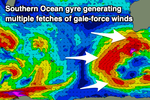
This will be thanks to a broad Southern Ocean gyre forming to our south, with multiple embedded low pressure centres rotating around a single point, driving fetches of gale-force winds through our south-western and southern swell windows.
The South West is due to become extra-large into the end of the week, building Thursday afternoon from the SW and peaking Friday out of the S/SW before easing into the weekend.
At this stage it looks like the South West will hit the 15ft range Friday, with Mandurah building to 4-5ft and 3-4ft in Perth through the afternoon. The swells will then ease into Saturday with dropping sets from the 12ft range in the South West, 4ft in Mandurah and 3ft across Perth.
It looks like we'll finally see the frontal activity back off into the weekend, with a high moving in which will bring easing and improving winds. Perth and Mandurah will improve earlier than the South West, with S/SE-SE winds due Saturday morning, with gusty S/SW tending S winds in the south, while Sunday should see much better E/NE winds across the South West.
Unfortunately by the time the winds shift offshore, the swell will be smaller and easing from 4-6ft out of the S/SW on the magnets, small in Perth and Mandurah.
Longer term there's nothing major on the cards for next week at this stage but we'll have a closer look at this on Wednesday.

