Poor surf continues in the South West
Western Australia Surf Forecast by Craig Brokensha (issued Wednesday June 7th)
Best Days: Perth and Mandurah today and tomorrow morning, the keen in the South West at some stage tomorrow, early Friday, Saturday morning Perth and Mandurah, possibly early Sunday Perth and Mandurah, Monday morning Perth and Mandurah
Features of the Forecast (tl;dr)
- Easing surf tomorrow with SW tending variable E/SE winds in the South West, variable offshore to the north
- Extra-large S/SW groundswell for Fri, peaking into the PM Perth and Mandurah
- Freshening N/NW-NW winds Fri, variable E/NE-NE at dawn
- Easing swell Sat with strong W/NW winds in the South West, N/NE-NE early in Perth and Mandurah
- Building large mid-period W/SW-SW swell for Sun with strong SW winds (possibly S/SE early Perth and Mandurah)
- Easing swell Mon with weaker SW winds in the South West, E/NE-NE Perth and Mandurah
Recap
Large, stormy waves across most locations yesterday, in the 12-15ft range across the South West, 4-5ft Mandurah and 4ft in Perth.
This morning the swell was still poor and easing in the South West, with more variable winds across Perth and Mandurah offering good peaky options to 3-4ft. Conditions should remain favourable all day in the metro locations with light afternoon winds.

Good waves across Perth and Mandurah today
This week and weekend (Jun 8 - 11)
Similar local conditions and winds are due tomorrow across the state with variable offshore winds in Perth and Mandurah tomorrow morning persisting out of the SW across the South West at dawn, but shifting more S/SE through the morning and light E'ly through the day as a trough drifts east away from us.
The swell will be on the ease though, dropping back from a weak 4-6ft in the South West on the magnets with 2ft sets across Perth and Mandurah.
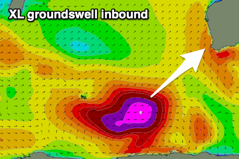
Into Friday we've got an approaching frontal system that will bring freshening N/NW tending NW winds, but early E/NE-N/NE winds are due across all regions along with the arrival of a strong new S/SW groundswell.

The source of this swell is a strong polar low that formed in the Heard Island region at the start of the week.
A fetch of severe-gale to storm-force W'ly winds is now weakening while projecting north-east, but wind speeds are still above gale-force.
The storm is expected to weaken further and transform into a eastward moving frontal system, leaving the long-period groundswell to arrive overnight tomorrow, peaking through the morning in the South West and a little later to the north.
Strong, powerful sets to 15ft are due in the South West, 4-5ft across Mandurah when it peaks and 3ft to occasionally 4ft in Perth though less consistent.
The winds will add issues apart from dawn unfortunately so lower your expectations.
Strong W/NW winds will unfortunately persist in the South West Saturday thanks to a deepening mid-latitude low moving in from the west as the swell eases, likely N/NE-NE early in Perth/Mandurah along with easing 3ft sets across Mandurah, 2-3ft in Perth.
Into Sunday, the low will cross us, bringing a new, large pulse of mid-period SW swell but with strong SW winds. There might be a window of early S/SE winds across Perth and Mandurah but we'll confirm this Friday.

The mid-latitude low will generate a strengthening fetch of strong to gale-force SW winds while pushing in, bringing a spike in mid-period swell to 10ft+ range across the South West, building to 3ft+ in Mandurah and 2-3ft across Perth in the afternoon but with strong SW winds.
Monday looks the pick for Perth and Mandurah with easing surf but with E/NE-NE morning winds, lingering out of the SW across the South West.
More frontal activity looks to develop south-west of us during next week, bringing more onshore winds and building surf, but we'll have a closer look at this on Friday.

