Strong S swell for Sunday with dicey winds
Western Australia Surf Forecast by Craig Brokensha (issued Friday May 26th)
Best Days: Sunday selected spots in the South West, afternoon Perth and Mandurah, all locations Monday morning, Perth and Mandurah Thursday morning
Features of the Forecast (tl;dr)
- Small Sat with morning E/NE-NE winds, shifting W
- Large S'ly groundswell Sun, with a small-mod W/SW groundswell building into the PM for metro locations, easing Mon
- Light W-W/NW winds in the South West (likely variable in the AM), E/NE to the north, tending variable into the PM
- Easing surf Mon with E/NE-NE tending NW winds
- Smaller Tue with strengthening N/NW winds
- Building W/SW and S/SW swells Wed with strong W/NW tending S/SW winds
- Easing surf Thu with early S/SE tending S/SW winds
Recap
A large S/SW swell peaked and cleaned up through the day across all locations yesterday, coming in at 8ft on the magnets in the South West, 2-3ft in Mandurah and 2ft+ across Perth.
Conditions are straight and great this morning but the swell is easing with 6ft sets in the South West, 2ft waves across Mandurah and 1-2ft sets in Perth. Conditions should remain favourable all day as the swell continues to ease.

Solid, lumpy surf yesterday

Cleaner and easing this morning
This weekend and next week (May 27 – Jun 2)
Heading into the weekend, we'll see the current swell continuing to ease with no much left on the magnets tomorrow morning, easing back from 3ft+ or so on the south magnets.
Conditions will be clean under a light E/NE-NE offshore wind ahead of a shallow W/SW change into the afternoon.
As touched on in Wednesday's notes, winds look to linger out of the W on Sunday, creating less than ideal conditions across the South West, while Perth and Mandurah will see morning E/NE winds.
There's a good chance for more variable breezes in the South West, producing workable conditions and this will with the arrival of a large, long-period but acute S'ly groundswell.

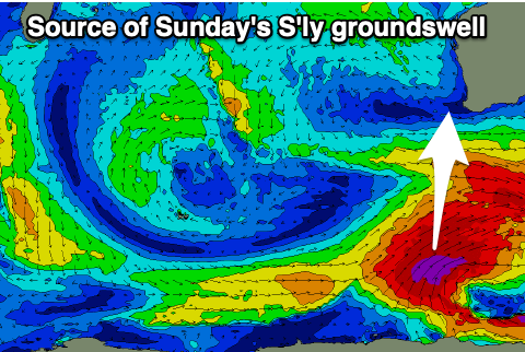
The swell is being generated today by a significant polar low that's formed to our south. A fetch of severe-gale SW winds will just be within our swell window (Margaret River) and produce acute and wide ranging long-period surf on Sunday. With the angle expect a wide variation of sizes with magnets due to come in at 8-10ft on the sets, bigger across the exposed southern coasts.
Perth and Mandurah aren't expected to see much size, building to 1-1.5ft and 1-2ft respectively through the afternoon.
A better source of inconsistent W/SW swell will arrive at the same time though for the metro locations, generated by a broad low that formed south of Madagascar earlier in the week. This should provide better 2ft sets at these locations along with variable sea breezes, easing from 2ft on Monday morning.
E/NE-NE winds look to develop across all locations on Monday as the W/SW and S swell eases, backing off from 2ft as stated above in metro locations and 6ft on the South West magnets.
Longer term a mid-latitude low is due to deepen while moving into us on Wednesday, bringing a poor, localised increase in W/SW and then S/SW swell as it passes.
Strong N/NW winds will create poor conditions Tuesday ahead of the low, strong W/NW tending SW as it pushes across us. There's a chance for S/SE winds on Thursday with a low quality, easing S/SW swell but we'll review this Monday.
Beyond this it looks like we'll see a run of strong mid-latitude frontal activity bringing large, onshore surf. Right on cue for the start of winter. More on this Monday. Have a great weekend!


Comments
Tow Foiling out Margs atm.