Fun surf tomorrow, deteriorating Sunday, better through next week
Western Australia Surf Forecast by Craig Brokensha (issued Friday April 28th)
Best Days: Tomorrow morning in the South West, Monday morning, Tuesday morning, Wednesday in the South West
Features of the Forecast (tl;dr)
- Easing mix of swells Sat with E/NE-NE winds ahead of weak sea breezes
- Building SW groundswells Sun, peaking in the PM with light-mod SW winds in the South West (possibly variable early), freshening
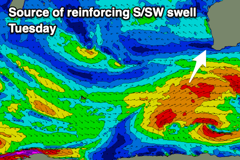
- Reinforcing mod-large sized mid-period S/SW swell Mon, easing slowly Tue and smaller Wed
- Moderate SE tending E/SE winds ahead of sea breezes Mon, fresh E/SE tending stronger S/SE winds on Tue
- Mod-fresh E/SE winds ahead of S/SE sea breezes Wed
- Smaller Thu with strong S/SE winds
- Moderate sized S/SW swell Fri with strong SE tending S/SE winds
Recap
Yesterday remained poor in the South West with some new swell building into the afternoon, peaking early this morning with lumpy, improving conditions under a light to moderate offshore wind. The exposed breaks were 8ft+ at dawn with a mix of mid-period S/SW swell and S/SW groundswell, easing since.
Perth and Mandurah were surfable yesterday morning with a small window of improving winds, cleaner this morning and easing from 2ft and 2-3ft respectively.
This weekend and next week (Apr 29 – May 5)
The current mix of swells will continue to ease in size and period tomorrow, with the South West dropping back from 4-6ft on the magnets 1-2ft in Mandurah and 1-1.5ft across Perth.
Light E/NE-NE winds will favour exposed breaks ahead of weak sea breezes, while Sunday morning now looks a little dicey with a trough due to bring SW winds (only light to moderate), with a chance for variable winds at dawn in the South West.
To the north, cleaner conditions are expected but with no real size.

Now after a temporary low point in swell at dawn Sunday, a new mix of SW groundswells are due to arrive mid-morning, building towards a peak into the afternoon. Firstly there'll be long-range energy from a polar fetch of gale to severe-gale NW winds to the west of the Heard Island region on Wednesday, while some close-range energy will be generated by W/NW gales that are currently south-west of us.
Size wise, the South West should build to 6-8ft into the afternoon but with freshening SW-S/SW winds across all locations, better Monday with SE tending E/SE winds and a reinforcing pulse of mid-period S/SW swell.
This will be generated by a trailing fetch of good, strong to gale-force S/SW winds pushing up behind the pre-frontal W/NW fetch, with surf holding in the 6ft to occasionally 8ft range across the South West, easing back from 6ft or so Tuesday morning.

Mandurah looks to be 2ft on the sets from Sunday afternoon through Tuesday morning, 1-2ft in Perth.
Conditions will be great Tuesday morning with a fresh E/SE offshore tending S/SE into the afternoon and then moderate to fresh E/SE winds Wednesday morning as the swell eases.
The size will drop slowly away across all locations into the end of the week, buffered a little by smaller mid-period S/SW swells Thursday afternoon but more so Friday.
The front bringing the reinforcing S/SW swell for later week will clip the state, bringing strong S/SE winds into Thursday, improving slightly and more SE on Friday but still strong. Longer term the outlook is a little slower, but more on this Monday. Have a great weekend!

