Pumping week of surf, trickier next week
Western Australia Surf Forecast by Craig Brokensha (issued Mnday April 17th)
Best Days: Tomorrow, Wednesday, Thursday (in the South West), Friday morning in the South West, Saturday morning, early Sunday, protected spots Tuesday morning next week
Features of the Forecast (tl;dr)
- Large mix of SW groundswell and mid-period swell building tomorrow, peaking later with E/SE-E tending S/SE winds in the South West (SE to the north into the PM)
- Easing SW swell Wed with fresh E tending moderate E/NE winds ahead of late sea breezes
- Smaller Thu with E/NE tending NE winds ahead of late sea breezes
- Low point in swell Fri AM ahead of new, building SW swell for the PM. Dawn E/NE winds, tending NE then giving into late sea breezes
- Mod-large mix of SW and building W/SW groundswell, peaking in the PM with moderate E/SE tending SW winds
- Easing swell Sun with early light winds, tending fresh SW
- Mod-large SW swell building Mon with strong S/SW winds, easing Tue with S/SE tending S/SW winds
Recap
Large, though onshore surf Saturday, easing across the South West with yesterday becoming smaller and remaining bumpy. Mandurah and Perth were great with light winds and clean, easing surf from 3-4ft and 3ft respectively on Saturday, 2-3ft and 2ft yesterday with a bit more north in the wind.
Today the swell is at a low point and a strong low is bringing strengthening W/NW winds that were light out of the NE in metro regions.
This week and weekend (Apr 18 - 23)
Today's strengthening W/NW winds are linked to a healthy, strong frontal progression that's currently south-west of us, clipping the state today before pushing east tomorrow.
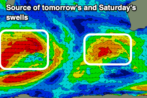
This progression developed as a strong polar low last week, to the south-southeast of South Africa, generating an inconsistent groundswell signal, while a larger, more consistent mid-period swell has been generated by it's push up towards us yesterday and today.
We should see both swells filling in tomorrow along with a rapid improvement in winds and condition. An offshore E/SE-E breeze is expected during the morning as the swell builds, with it due to reach 10ft in the South West (with the odd bigger cleanup set likely on dark), 3ft in Mandurah late afternoon and 2-3ft in Perth. Winds now look favourable all day and only tending SE to the north, S/SE to the south, providing a full day of good surf.

The swell should start easing through Wednesday, back from 8ft to possibly 10ft in the South West, 2-3ft in Mandurah and Perth. Fresh E'ly winds will create great conditions, easing and tending E/NE ahead of relatively weak, late sea breezes.
Thursday looks smaller and back to 4-5ft+ on the sets across the South West magnets, 1-2ft to the north along with a moderate E/NE tending NE breeze ahead of weak, late sea breezes.
A very temporary low point is due Friday morning along with similar winds to Thursday, though tending NE fairly soon after dawn.
During the day, a new pulse of mid-period W/SW swell should build, followed by a better pulse of W/SW groundswell into Saturday.
The source of these swells will be the same frontal progression, with the strongest stage of it currently sitting south-east of Madagascar. That being a fetch of W'ly gales that formed south of Madagascar on the weekend, and it's now beginning to weaken and break down while dipping south-east across the Heard Island region.
This will generate an inconsistent W/SW groundswell for Saturday, peaking through the afternoon to 6-8ft in the South West, 2-3ft in Mandurah and 2ft across Perth. The mid-period energy ahead of it on Friday should build to 5-6ft and 1-2ft respectively in Margs and Perth/Mandurah.
It's worth nothing that also in the mix on Saturday will be a close-range SW swell, likely there in the morning and to 6ft to possibly 8ft, generated by a tight, intense but fast east tracking low Thursday/Friday. With the mix of swells we might see some funky sets spoiling each other but also the odd crazy double-up. Keep in mind though that EC has a much weaker system and less size, so we'll review this additional energy on Wednesday.
Locally winds on Saturday look good as a trough brings a change overnight Friday, with winds swinging back E/SE for the morning ahead of afternoon sea breezes.
Sunday looks a touch dicier with early, light local offshore winds ahead of a trough and SW change later morning.
This trough will be attached to a strong low forming south-west of us on the weekend, with it due to generate a fetch of W/SW gales, followed by strong SW winds pushing up into the state on Monday.
This will bring average, strong S/SW winds through Monday to all locations as the groundswell fills in, coming in at 8ft+ in the South West, 2-3ft across Mandurah and Perth.
Tuesday should see easing surf as wind tend back to the S/SE but remain strong, possibly lingering Wednesday. The models diverge on the wind/swell outlook for the rest of the week so check back Wednesday for an update.

