Good weekend in the north, much better in the South West next week
Western Australia Surf Forecast by Craig Brokensha (issued Friday April 14th)
Best Days: Metro locations Saturday and Sunday, Tuesday, Wednesday, Thursday in the South West, Friday morning in the South West, next Saturday
Features of the Forecast (tl;dr)
- Large, mid-period SW swell easing tomorrow with S/SW tending W/SW winds in the South West, light E to the north ahead of weak sea breezes,
- Further drop in size Sun with similar winds to tomorrow, smaller Mon with strengthening W/NW winds (variable early Perth and Mandurah)
- Large mix of SW groundswell and mid-period swell building Tue, peaking later with E/SE tending S/SE winds in the South West (S/SW to the north)
- Easing SW swell Wed with gusty E/NE tending light N/NW winds
- Smaller Thu with E/SE tending SW winds
- Low point in swell Fri AM ahead of new groundswell later. Light E/SE tending SW winds
- Mod-large W/SW groundswell Sat with E/SE tending S/SW winds
Recap
Terrible conditions across the South West with stormy, building swell and poor also in Perth and Mandurah under strengthening NW winds as a strong cold front pushed up and across us.
This front is clearing east today resulting in an improvement in conditions across selected spot temporarily this morning along with an oversized mix of swells. Margs is still choppy and to 12ft or so, best in protected spots with lumpy 3-5ft waves across Mandurah and 3-4ft surf in Perth. A brief period of lighter S/SE winds in Perth and Mandurah has now reverted back onshore.
This weekend and next week (Apr 14 - 21)
Today's oversized mix of groundswell and mid-period energy will start easing into the weekend as we see a temporary weakening of the frontal activity pushing up and across the state.
Unfortunately for the South West though, lingering weak activity will keep onshore winds blowing and conditions poor for the most part. Perth and Mandurah will be far enough north to see local land breeze effects kick in along with weak sea breezes. A light, offshore E tending E/NE breeze is due tomorrow ahead of weak sea breezes, S/SW tending W/SW in the South West.
Easing surf from the 10ft range is due in the South West, 3ft+ across Mandurah and 3ft on the sets in Perth. Similar winds are due on Sunday (W/SW in the South West though) as the swell backs off further from 6ft to occasionally 8ft in the South West, 2-3ft in Mandurah and 2ft in Perth.
Monday looks smaller along with strengthening W/NW winds (variable early Perth and Mandurah as our swell producing front for Tuesday edges in.

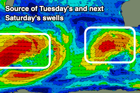
Now, as touched on in Wednesday's update, the front begun its life as a strong low to the west of the Heard Island, generating a moderate-large, long-range SW groundswell, but the remnants are now projecting a fetch of strong to gale-force W/SW winds slowly up towards us. This will generate an additional large, mid-period SW swell, with both arriving through Tuesday, building towards a peak later.
The South West should build and peak to the 10ft range, with the odd bigger cleanup set likely on dark, 3-4ft in Mandurah and 2-3ft across Perth, easing back from 10ft, 3ft and 2-3ft respectively Wednesday morning.
Winds look great owing to the swell generating front clearing to the west, bringing E/SE offshore breezes to all locations, tending S/SE in the South West and S/SW to the north. Wednesday will see gusty E-E/NE winds, creating excellent conditions with the large, easing surf.
Thursday will see the swell drop further in size and power but morning E/NE winds will create clean conditions ahead of N/NW sea breezes, only light.
Our next pulse of swell is due later Friday, generated by a strong mid-latitude storm forming south of Madagascar, pushing east while generating a broad fetch of W/SW gales before weakening north-east of the Heard Island region.
We'll see remnants of this storm continuing to generate patchy fetches of strong to gale-force W/SW winds while pushing east towards us through next week, with a moderate-large mix of inconsistent W/SW groundswell and moderate sized mid-period SW swell due from later Friday but more so next weekend.
Saturday should come in around 6-8ft in the South West, 2ft+ in Mandurah and 2ft on the sets in Perth along with morning E/SE offshore winds. We'll take a closer look at this on Monday though. Have a great weekend!


Comments
The WSL might finally be in luck
Yep, FC article being made as you read.
Are NP/Box an option this year?
Box I'd say yes, but NP not sure, won't need it but.
Cheers Craig.
Any chance of winds going N - N/W on Sunday?
Not down Margs way, W/NW at best later.
What about for the metro area?
Briefly N-N/NW late morning then W/SW into the arvo.
Did ya get the window?
of course it'll start cranking when everyones lookin at it
It would have been good to see Cable beach cranking the other day. The surf cam at Zanders is never working. Probably a good thing.