Good waves in metro locations from Friday
Western Australia Surf Forecast by Craig Brokensha (issued Wednesday April 12th)
Best Days: Protected spots Friday, Perth and Mandurah Saturday and Sunday, Tuesday and Wednesday all locations
Features of the Forecast (tl;dr)
- Large SW groundswell building tomorrow with strong NW tending W/SW winds into the PM
- Oversized mix of swells Fri with strong S/SW winds (possibly S-S/SE dawn in Perth and Mandurah)
- Large, easing mid-period SW swell Sat with light E/NE-E tending light W winds in Perth Mandurah, gusty S/SW tending SW in the South West
- Further drop in size Sun with similar winds to Sat (moderate W/SW-W in the South West)
- Low point in swell Mon AM with similar winds to Sun
- Large new mix of long-range SW groundswell and mid-period SW swell building Tue with SE tending SW winds
- Easing surf Wed with fresh E/NE tending variable winds
Recap
Poor surf across most locations yesterday morning with a mix of SW groundswell and mid-period W/SW swell (more so to the north) but with improving conditions after lunch in Perth and Mandurah as onshore winds moderated.
This morning the South West is still a mess, while Perth and Mandurah saw variable morning winds and 2ft to occasionally 3ft sets.
This week and weekend (Apr 13 - 16)
Winds will strengthen again into tomorrow, coming out of the NW ahead of a W/SW change into the afternoon, reaching Perth and Mandurah more towards the evening as a broad, strong polar frontal system pushes up and towards us.

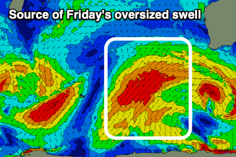
The front will be quite significant in scope but relatively weak in nature (compared to what we can see) but we'll still see an elongated swathe of strong S/SW-SW winds projected through our south-western swell window, kicking up a large mid-period SW swell for Friday, mixed in with stronger levels of groundswell.
This will be on top of a new SW groundswell due tomorrow, with the size due to slowly rise ahead of a peak Friday to 12ft+ in the South West, 3-5ft in Mandurah and 3-4ft in Perth.
Winds will be strong from the S/SW on Friday, with an outside chance of S-S/SE winds around Perth and Mandurah for a short period in the morning, so try protected spots.
Saturday looks much cleaner and better in Perth and Mandurah with a light E-E/NE offshore (S/SW in the South West) along with easing levels of mid-period swell from 10ft in the South West, 3ft+ across Mandurah and 3ft in Perth. Sea breezes will be weak as well, providing decent surf most of the day.
Sunday looks smaller and winds should again be light offshore for Perth and Mandurah while the South West will see lingering W/SW-W winds. Similar conditions will play out Monday with the swell bottoming out.

The next pulse of swell is due to fill in Tuesday, peaking through the afternoon/evening and it'll be a mix of long-range energy and close-range swell.
The source is a polar low that's forming to the west of the Heard Island region today, with an initial fetch of gale to severe-gale, pre-frontal W/NW winds due to be then followed by strong to sub-gale-force W/SW winds, projecting slowly up towards us through the weekend, clipping us Monday.
There'll be a mix of periods with building surf on Tuesday to 8-10ft in the South West, 3ft across Mandurah and 2-3ft in Perth along with (hopefully) much better E/SE-SE morning winds ahead of sea breezes. As the swell eases we'll likely see gusty E/NE winds, but we'll have a closer look at this on Friday.


Comments
https://earth.nullschool.net/#current/wind/surface/level/orthographic=-2...
I just came down from looking at that myself.
Just mental. News reporting it could be around 315km/hr as it hit the coast.