New swell today, stronger surf into the end of the week
Western Australia Surf Forecast by Craig Brokensha (issued Wednesday March 29th)
Best Days: Today in the South West, tomorrow morning in the South West, Friday, Saturday morning, Sunday morning in the South West, Tuesday morning
Features of the Forecast (tl;dr)
- Small, inconsistent W/SW groundswell building slowly Wed, peaking later, easing Thu
- Fresh E/SE tending S/SE winds late Wed
- Strong E/SE tending S/SE winds Thu
- Moderate + sized S/SW groundswell for Fri with mod-fresh E/SE tending S/SE winds
- Slowly easing swell Sat with mod-fresh E/SE tending S/SW winds
- Smaller Sun with moderate E/SE tending S/SW winds
- Inconsistent W/SW groundswell building Mon, peaking into the late PM with fresh S/SE tending S/SW winds
- Easing swell Tue with mod-fresh E/SE-SE tending S/SW winds
Recap
Clean but small, fading surf through yesterday to 2-3ft in the South West, tiny elsewhere.
This morning was similar in size with great conditions but some new, inconsistent W/SW groundswell sets are showing with a peak due into this afternoon on the sets to 4ft (1-1.5ft Mandurah and Perth). It looks like sets are already in this range and winds should remain favourable until mid-late afternoon.

New inconsistent W/SW groundswell in the water
This week and weekend (Mar 30 – Apr 2)
This afternoon's inconsistent W/SW groundswell is due to slowly ease through tomorrow from a similar size, with sets being very slow. Conditions will be windy but favourable with a strong E/SE offshore that will shift S/SE into the afternoon.
We then look towards our S/SW groundswell due Friday, with the polar frontal progression linked to this now pushing east out of our swell window.
Through yesterday a great fetch of gale to severe-gale W/SW winds were generated, with a weaker trailing fetch of SW gales today, just sitting within our swell window.

A moderate sized + S/SW groundswell is due from the initial fetch Friday, with the easing trend slowed by the trailing fetch into Saturday.
Good 6ft+ sets are due across the South West with 2ft sets in Mandurah and 1-2ft waves across Perth, easing from 4-5ft on Saturday, 1-2ft in Mandurah and Perth.
Locally winds look great with a gusty E/SE offshore Friday morning, shifting S/SE into the afternoon and moderate to fresh E/SE winds on Saturday ahead of S/SW sea breezes.
Sunday will be best in the South West as the S/SW swell eases further under a morning E/SE offshore.
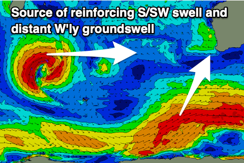
Longer term we've got a small to moderate sized mid of W'ly groundswell and mid-period SW swell due to build Monday ahead of a peak into the evening, easing Tuesday.
The source of the W'ly swell is a mid-latitude low that's formed south of Madagascar (above left) and is generating a small fetch of W'ly gales while moving slowly east. This should produce some fun though inconsistent W'ly swell to 4-6ft in the South West, 2ft in Mandurah and 1-2ft across Perth Monday afternoon/evening.
The remnants of the low will generate smaller, weaker levels of mid-period SW swell.
Locally winds on Monday aren't great, shifting S/SE to S/SW through the day, with Tuesday cleaning up through the morning with an E/SE-SE offshore as the swell eases.
Longer term there's nothing too significant on the cards so make the most of the current coming swell.

