Small ahead of a good swell later week
Western Australia Surf Forecast by Craig Brokensha (issued Monday March 27th)
Best Days: Every morning this week for the keen in the South West, Friday morning all locations, Saturday morning in the South West and Mandurah
Features of the Forecast (tl;dr)
- Easing swell tomorrow with fresh E/SE tending S/SE winds
- Small, inconsistent W/SW groundswell building slowly Wed, peaking later, easing Thu
- Fresh E/SE tending S/SE winds late Wed
- Fresh SE tending S/SE winds Thu
- Mod-large S/SW groundswell for Fri with mod-fresh E/SE tending S/SW winds
- Easing swell Sat with E/SE tending S/SW winds
Recap
Average surf across the South West in the 3ft range with cross-offshore winds, cleaner to the north and best Saturday morning with 1-1.5ft surf, tiny yesterday.
This morning is a bit cleaner in the South West and still in the 3ft range, tiny to the north.

Small set this AM
This week and weekend (Mar 28 – Apr 2)
The majority of the coming week isn't overly special swell wise, but we do have some favourable winds and a good pulse of S/SW groundswell due later week.
Tomorrow is due to ease back from today's size with fading 2-3ft sets across the South West magnets, tiny to the north and with a morning E/SE offshore, strengthening from the S/SE into the afternoon.
On Wednesday, an inconsistent, long-range W/SW groundswell is due to build, with it generated by a small but intense low around Madagascar last week. It should kick to an very inconsistent 4ft through Wednesday afternoon, smaller in the morning with 1-1.5ft sets to the north before easing from a similar size range on Thursday.
Winds will be favourable most of Wednesday and gusty out of the E/SE before shifting S/SE later, more SE Thursday morning before strengthening from the S/SE into the afternoon.

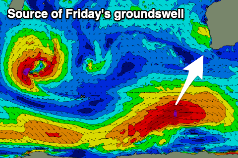
Of greater importance is a good pulse of S/SW groundswell due into Friday. This will be generated by a strengthening polar frontal system to the south-southwest of us over the coming days. A fetch of broad gale to severe-gale W/SW winds will be generated through our southern swell window, with the groundswell due to arrive Thursday evening before peaking Friday to the 6ft+ range in the South West, 2ft in Mandurah and 1-2ft across Perth.
Conditions look great with an E/SE offshore due across most locations ahead of sea breezes, similar Saturday morning as the swell eases.
Following this the outlook appears slower, so make the most of the coming window of fun surf in the South West.

