Average end to the week, much better weekend
Western Australia Surf Forecast by Craig Brokensha (issued Wednesday March 15th)
Best Days: Mandurah tomorrow morning, Perth and Mandurah for the keen Friday morning, South West for the keen Saturday morning, Sunday and Monday until sea breezes develop
Features of the Forecast (tl;dr)
- Easing surf tomorrow with strengthening N/NW winds ahead of a weaker SW change (variable early Perth and Mandurah)
- Weak W/SW swell Fri with strong S/SW-S/SE winds (S/SE Perth and Mandurah in the AM)
- Small background swell Sat with E/SE tending S/SW winds
- Mod-large S/SW groundswell building Sun, easing slowly Mon
- Gusty E/SE tending E/NE-E winds, then variable ahead of late sea breezes
- Easing swell Mon with moderate E/NE tending NW winds
Recap
Pumping surf yesterday morning with a peak in our SW swell energy coming in at 8ft across the South West, 3ft in Mandurah and building to 2-3ft across Perth. Conditions were best in the morning ahead of afternoon sea breezes.
This morning conditions were a little funky in the South West with northerly winds and a drop in swell ahead of a trough, while Perth and Mandurah were still clean and to 2ft.


Solid set out the back in the South West, with strong arvo lines in Perth
This week and weekend (Mar 16 - 19)
The end of the week looks poor for surf with the current swell energy due to ease further and winds will shift onshore as a front approaches with strengthening N/NW winds ahead of a SW change in the South West, variable to the north but small to tiny. Perth looks to ease from 1-1.5ft while Mandurah might still see 1-2ft sets early.
Friday will become smaller in the South West and gusty S/SW-S/SE winds will create bumpy/choppy conditions. Perth and Mandurah are likely to see some weak, W/SW swell energy to 1-2ft though from tomorrow's trough.
Winds will start to improve on the weekend as a large new S/SW groundswell fills in and peaks Sunday afternoon.
Ahead of this though Saturday looks small with a mix of mid-period swells to 3ft+ in the South West along with a morning E/SE breeze.

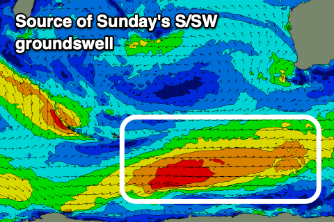
More importantly, looking at Sunday's swell and a polar low that's formed west of the Heard Island is generating a fetch of strong to just gale-force strength winds and will project east and then east-northeast at a similar strength through the end of the week before pushing east of our swell window early Saturday morning.
A moderate-large S/SW groundswell is due from this source, building Sunday and reaching 6ft+ across the South West (8ft sets likely on the magnets), 2ft in Mandurah and 1-2ft in Perth.
Winds look great Sunday morning and gusty out of the E/SE as the swell builds, tending more E/NE through the day and variable into the afternoon ahead of late sea breezes.
Weaker winds should be seen Monday out of the E/NE as the swell starts easing from a similar size in Perth and Mandurah, more 6ft in the South West.
A trough will likely bring unfavourable S/SE winds into Tuesday as the swell eases further, so make the most of Sunday and Monday. Longer term moderate to possibly large mid-period/groundswell energy is due mid-late week but with S/SE-SE winds, more on this in Friday's update.

