Great surf from Friday
Western Australia Surf Forecast by Craig Brokensha (issued Wednesday February 22nd)
Best Days: Friday morning, Saturday morning Margs, Sunday morning Margs and Mandurah, Monday morning Margs and Mandurah
Features of the Forecast (tl;dr)
- Moderate + sized mid-period SW swell later tomorrow, peaking Fri AM, easing into Sat
- Mod-fresh E/SE winds ahead of strong S-S/SW winds Fri and Sat
- Moderate + sized SW groundswell building Sun, with a reinforcing pulse for Mon AM, easing
- Mod-fresh E tending variable and then SW winds
- E/NE tending S/SW winds
Recap
Clean easing surf yesterday with fun options across the South West magnets until winds went onshore mid-morning.
Today the swell is small to tiny and with less favourable winds across all locations.
This week and weekend (Feb 24 - 26)
Tomorrow will be another lay day as the morning starts of small to tiny again, but into the afternoon some new mid-period SW swell should build ahead of a peak Friday morning.
Before looking at Friday's swell, winds tomorrow will remain poor and strong from the S'th as the remnants of a low linked to the swell pushes up and into us as a weaker trough.
This swell generating low formed earlier this week around the Heard Island region, with a fetch of sub-gale-force W/NW-W/SW winds projected slowly east-northeast towards us. The low is now weakening and we'll see the swell arriving tomorrow afternoon but peaking Friday morning to 6ft+ in the South West, 2ft across Mandurah and 1-2ft in Perth.
Winds should improve, tending E/SE on Friday morning and be moderate to fresh before strong S-S/SE sea breezes kick in, with Saturday playing out similar wind wise as the swell eases from 4-5ft in Margs, 1-1.5ft to the north.

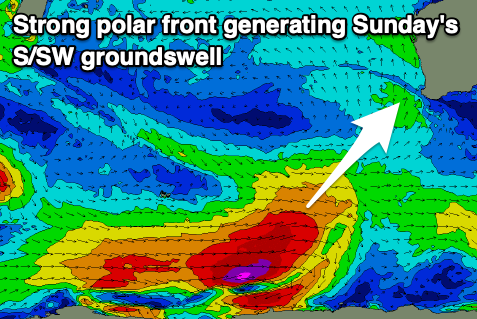
Our reinforcing S/SW groundswell for Sunday is looking a touch stronger, with the polar front linked to it now expected to generate a great fetch of severe-gale W/SW winds through our southern swell window.
The swell should be in the water Sunday morning, peaking into the afternoon to 5-6ft across the South West, 1-2ft in Mandurah and 1-1.5ft across Perth.
Winds look great with E'ly offshore winds Sunday morning, variable into the early afternoon ahead of sea breezes.
Winds look to remain favourable Monday with an E/NE offshore ahead of a S/SW change as a trough clips the state. The swell should still be up around 4-6ft on Monday morning owing to a lingering fetch of gales on the polar shelf through Friday before pushing east.
Longer term we're looking at a slow period of waves with the Southern Ocean storm track going quiet so make the most of the coming period of surf.

