Fun tomorrow morning, with solid surf for the weekend but average winds
Western Australia Surf Forecast by Craig Brokensha (issued Wednesday December 28th)
Best Days: Tomorrow morning in the South West, protected spots Saturday morning and late in the day, similar Sunday and Monday, exposed magnets in the South West Tuesday and Wednesday mornings
Features of the Forecast (tl;dr)
- Easing SW swell Thu with light-moderate E/SE winds ahead of late AM sea breezes
- Building S/SW groundswell Fri with strong S/SE winds, shifting S/SW-SW winds
- Better moderate-large sized SW swell building Sat, peaking late in the day/Sun AM, with a secondary slightky smaller pulse Sun PM, peaking Mon AM,
- Mod-fresh S-S/SE tending S/SW-SW winds on Sat, fresh SE tending strong S/SW-SW winds Sun
- Easing surf Mon PM with gusty SE tending S/SE winds
- Smaller Tue with E/SE tending S/SE-SW winds
Recap
Poor conditions across the South West yesterday with strong S/SW winds and a building mid-period SW swell, while Mandurah offered OK waves in protected spots, poor across Perth and tiny.
Today winds have swung offshore, cleaning up the mid-period swell energy with great 6ft+ waves in the South West (a little better than expected), 2ft surf in Mandurah while Perth remained tiny.


Solid sets this AM
This week and next (Dec 29 - Jan 6)
We'll see the current swell easing through the day, becoming smaller tomorrow and favouring the exposed magnets around the South West. Conditions look great with an E/SE offshore, giving into sea breezes late morning out of the SW.
Friday morning will see a temporary low point in swell and this will be as winds deteriorate due to a trough pushing in tomorrow evening, clipping the state. Strong S/SE winds are due in its wake, shifting S/SW into the afternoon across the South West and SW to the north as a polar front pushes up and towards us.

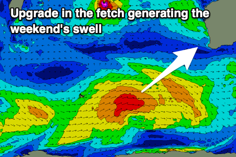
Now, this front will be associated with a healthy polar frontal progression that's currently south-west of us (and looking a touch stronger than on Monday), with moderate-large pulses of mid-period SW swell expected from Saturday through Sunday, easing Monday across the state.
The first and best pulse of swell is being generated by an elongated fetch of strong to at times just gale-force W/SW winds across the Heard Island region. This will build Saturday, reaching a peak later in the day to 6-8ft in the South West, 2-3ft in Mandurah and 2ft across Perth.
The swell should ease from a similar size on Sunday morning, with a smaller reinforcing pulse due to maintain 6ft sets into Monday morning across the South West, 2ft Mandurah and 1-2ft in Perth before easing.
Winds will will be less than ideal Saturday and moderate-fresh S-S/SE tending stronger S/SW, with Sunday due to see more favourable SE winds for a short period in the morning, best Monday with a longer lasting gusty SE breeze.
We'll see winds slowly swing more offshore each morning into Tuesday and Wednesday but with easing levels of swell, best across the South West magnets.
Small pulses of mid-period S/SW swell are on the cards for Wednesday afternoon and Thursday along with morning offshores, but beyond this the outlook remains quiet. We'll look at this again Friday.


Comments
No complaints from down this way. December ending with a beautiful bang.
It's been a good run eh!
You betchya!! Hope the same over there for you.
Yep, just getting started!