Good conditions and surf continue
Western Australia Surf Forecast by Craig Brokensha (issued Friday December 16th)
Best Days: The South West today and tomorrow morning, Sunday morning, the South West Monday morning and Wednesday morning, Thursday morning
Features of the Forecast (tl;dr)
- Inconsistent SW groundswell tomorrow, with a slightly bigger, reinforcing W/SW swell for the PM, easing Sun
- Strong, easing E/SE-E winds ahead of sea breezes Sat, similar Sun but more E in the AM
- Easing surf Mon with strong but easing E winds ahead of sea breezes
- Large mix of SW groundswells building Wed PM holding Thu AM, then easing
- Strong SE tending S/SE winds Wed (S/SW to the north)
- Fresh to strong E/SE-SE tending S/SW-SW winds Thu
- Smaller Fri with S/SE-SE winds
Recap
Windy and small to tiny yesterday with sea breezes kicking in late morning. Today we've got much better surf with a new SW groundswell, great conditions and sets to 4-5ft in the South West. Mandurah is 1-1.5ft but mostly a tease with tiny waves across Perth. Make the most of the clean conditions in the South West before sea breezes kick in.

Good sets at dawn this AM
This weekend and next week (Dec 17 - 23)
Fun surf should continue across the South West over the coming period as reinforcing pulses of swell fill in, the best tomorrow afternoon/Sunday morning.
These swells were generated by persistent frontal activity to the south-east of South Africa, with tomorrow afternoon's and Sunday morning's slightly more west pulse produced by a closer, more northerly positioned front pushing above the Heard Island region.
We should see tomorrow continuing around 4-5ft in the South West, 1-1.5ft across Mandurah but the new swell should lift the energy slightly to 4-6ft and 1-2ft in Mandurah and Perth.
Morning, strong E/SE-E winds are due to ease before giving into sea breezes around midday, spoiling the new pulse of energy.
Sunday will be the pick for the most size and cleanest waves with a strong E wind again, easing and tending variable ahead of late morning sea breezes (delayed to the north).

Expect winds to play out similar to Sunday on Monday but with easing surf, back from 4-5ft and 1-1.5ft respectively.
Tuesday looks smaller and we'll see winds dip back a little more to the E/SE-SE across the South West (E-E/NE to the north) as a deepening heat trough along the coast starts to squeeze a high passing slowly under us.
Wednesday will see the effects of this heat trough with stronger SE winds during the morning and S/SE-S/SW sea breezes into the afternoon as our new SW groundswell arrives.
The source of this swell is a strong polar low that's formed south of South Africa. The low is strong but distant, with a fetch of severe-gale W/SW winds (couple of storm-force bursts) projecting east, before weakening into this evening.
The swell will be inconsistent but should pulse to a good 6ft+ (8ft sets magnets) across the South West later Wednesday, easing from a similar size Thursday morning with 1-2ft sets across Mandurah and Perth.
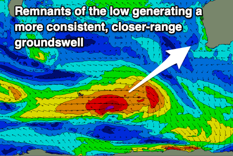
Mixed in with this swell is due to be a more consistent, closer-range SW groundswell, produced by the remnants of the low, pushing east, north of the Heard Island region and generating a fetch of W/SW gales.

This should produce similar sized surf, also arriving Wednesday afternoon but with more consistent 2ft sets in Perth and Mandurah,.
Thursday morning looks nice and clean again with E/SE-SE winds ahead of sea breezes, less favourable and from the S/SE-SE Friday as the swell eases.
Longer term, the outlook is slower, but more on this Monday. Have a great weekend!

