Fun, weekend waves
Western Australia Surf Forecast by Craig Brokensha (issued Friday December 9th)
Best Days: Tomorrow morning all locations, Sunday morning in the South West, Tuesday later morning for the keen in the South West, Friday morning in the South West
Features of the Forecast (tl;dr)
- Moderate sized + SW swell Sat AM, easing with moderate S/SE (SE at times) tending strong S/SW winds
- Easing surf Sun with mod-fresh E/SE-ESE tending strong S/SW winds
- Fading surf early next week with strong E/SE-E morning winds Mon
- Small SW swell Tue with strong morning E/SE winds
- Inconsistent SW groundswell for Thu PM, peaking Fri with E tending SW winds
Recap
Conditions were favourable across the South West yesterday morning and with a bit of size still in the mix, dropping from 4-5ft. Perth and Mandurah were also clean but tiny and to 1-1.5ft.
Today, an inland low/trough is starting to move east, bringing onshore winds to Perth, lighter and more variable across Mandurah and Margs along with clean conditions and fun surf. A new mid-period SW swell is providing 4ft sets in the South West while the waves remain tiny to the north.

This weekend and next week (Dec 10 - 16)
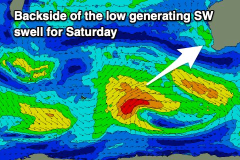
The weekend ahead looks fun for surf thanks to a new, moderate + sized mid-period SW swell arriving overnight, peaking tomorrow morning. This swell was generated by a broad, healthy low to our south-west this week.
Sets to 5-6ft are due in the South West, 2ft across Mandurah and 1-2ft in Perth tomorrow morning, easing through the day. Winds will tend S/SE tomorrow morning (possibly SE at times) as a high starts moving in slowly from the west, with cleaner conditions Sunday under an E/SE-SE offshore. Strong afternoon sea breezes will create bumpy conditions each day so surf before lunch.

Sunday will be smaller and easing from the 4ft range, tiny across Perth and Mandurah. Into Monday the swell will be on the way out under stronger E/SE-SE winds, fading from 2ft to possibly 3ft on the swell magnets.
The models are showing a small uptick in size on Tuesday but the source is a brief, poorly aimed fetch of NW winds. I'd not expect anything over 3ft in the South West but with strong, morning E/SE winds again.
Offshore winds will continue to blow through the rest of the week as high pressure sits to our south and south-west. The blocking effects of the highs will keep the swell on the smaller side unfortunately, flat across Perth and Mandurah and small to tiny in the South West. A good period to go snorkelling/diving.

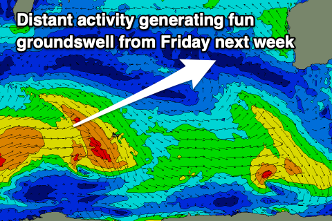
Later in the week a new prolonged SW groundswell is likely, generated by a flurry of distant frontal activity to the south-east of South Africa and west of the Heard Island region.
At this stage it looks to be inconsistent and moderate in size, with swell from Thursday afternoon through Monday the following week under morning offshore winds. We may see west winds into Monday week, but this is too far down the track.
The South West looks to ebb and pulse between 4-5ft or so, tiny and to 1.5ft to the north but we'll review this Monday. Have a great weekend!

