Mostly small week, increasing in energy on the weekend
Western Australian Surf Forecast by Craig Brokensha (issued Monday April 11th)
Best Days: South West swell magnets every morning this week, protected spots Saturday morning and Sunday morning all locations
Features of the Forecast (tl;dr)
- Easing SW groundswell tomorrow with moderate SE tending E/SE winds ahead of strong S'ly sea breezes
- Small, inconsistent SW groundswell for Wed, easing Thu with SE-E/SE morning winds Wed and E'ly winds Thu
- Inconsistent mid-period SW swell building Fri with E/NE tending SW winds
- Moderate sized SW groundswell for Sat with fresh S/SE winds, strengthening
- Possible larger swell Sun with strong SE tending S/SE winds
Recap
Lumpy workable waves across all locations on Saturday morning with Perth and Mandurah offering the cleanest conditions. A reinforcing mid-period swell provided 2ft sets with 4-5ft waves across Margs.
Sunday was poor with a cold front clipping the South West though Perth and Mandurah early light winds and cleaner conditions again with a reinforcing, infrequent SW groundswell.
Conditions have cleaned up today with plenty of size still in the mid to 6ft across the South West along with 2ft sets in Perth and Mandurah.
This week and weekend (Apr 12 - 17)
Looking at the week ahead and we’ll see the current inconsistent SW groundswell easing into tomorrow, but with good conditions through the mornings.
SE tending E/SE winds are due tomorrow morning before strong S’ly winds kick in with easing sets from 4ft in the South West, 1-1.5ft across Perth and Mandurah.
Come Wednesday, an inconsistent, long-range SW groundswell should fill in but the models are over-forecasting the size, with this swell mixing with the easing mid-period energy.
Infrequent surf in the 4ft range should continue across the South West, with Perth and Mandurah dropping back further to 1ft.
Winds will be light from the SE-E/SE again in the morning before gusty S’ly winds kick in after lunch.
The swell is due to ease into Thursday with morning E’ly winds, fresher Friday along with a new, building mid-period SW swell.
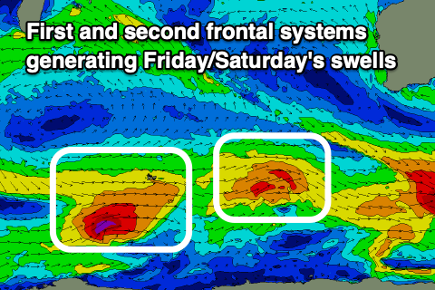
 This will be generated by a small polar front firing up from the Heard Island region, generating a burst of W/SW gales, with a secondary stronger front firing up behind it. There’s even a third on the cards, with each one generating a slightly stronger and better pulse of groundswell from Friday through the weekend.
Friday’s pulse should reach 4-5ft in the South West with tiny waves to the north, with the secondary pulse Saturday coming in at 5-6ft with inconsistent 1-2ft sets in Mandurah and 1-1.5ft across Perth. Sunday looks biggest with 6ft+ sets in the South West, 2ft waves in Mandurah and Perth (check back Wednesday for confirmation).
E/NE breezes are due on Friday morning while a trough looks to bring a S/SE change on Saturday with gusty SE winds Sunday morning. We’ll confirm this in Wednesday’s update though.
Longer term we could be looking at one of the stronger swell generating systems we’ve seen this year develop along the polar shelf, but more on this Wednesday.

