Windy couple of days, improving later week
Western Australia Surf Forecast by Craig Brokensha (issued Monday February 28th)
Best Days: Protected spots Wednesday morning Margs and Mandurah, every morning from this Thursday through next Wednesday in the South West
Features of the Forecast (tl;dr)
- Inconsistent mid-period SW swell building today, peaking tomorrow morning with a stronger pulse of less consistent groundswell later in the day, easing Wed
- Mod-fresh S/SW winds tomorrow (SW in Perth and Mandurah tomorrow morning), strong S/SE Wed AM, tending S'ly into the PM (fresh S/SE Perth and Mandurah in the AM)
- Mod-fresh S/SE winds Thu AM as the swell eases (SE Perth and Mandurah)
- Building mid-period SW swell Fri with E/SE tending strong S/SW winds, peaking Sat with E/SE tending S/SW winds
- Easing swell Sun with fresh E/NE tending NW winds, with a reinforcing SW swell building Mon, peaking Tue with morning SE winds
Recap
A poor weekend of surf with windy conditions and small amounts of swell. Today is much better with a light offshore wind and building mid-period SW swell. The swell should reach 4ft+ this afternoon but with sea breezes.
This week and weekend (Mar 1 - 6)
Wind, that's our main problem over the coming days. We're expecting some better sized mid-period swell tomorrow as well as a stronger pulse of groundswell for later in the day but a trough will bring poor, moderate to fresh S/SW winds across all locations tomorrow morning (SW in Perth and Mandurah).
Size wise today's mid-period SW swell should peak tomorrow morning to 4-6ft across the South West with 1-1.5ft waves in Mandurah and 1ft+ sets across Perth. Into the late afternoon some stronger but inconsistent SW groundswell is due from a strong low that formed late last week west of the Heard Island region. This should kick wave heights to 6ft+ later in the day, easing from a similar size Wednesday morning.
Winds Mandurah should see 1-2ft sets on Wednesday morning, tiny in Perth and winds will improve a touch and be best for protected spots with strong S/SE winds in Margs, moderate to fresh in Perth and Mandurah, strengthening from the S'th through the day.
Winds look to slowly ease on Thursday as the trough starts to clear to the east with a moderate to fresh S/SE breeze due in the South West, SE in Perth and Mandurah with easing sets from 4-5ft. Perth and Mandurah will become tiny and this looks to remain the trend into the weekend and next week with small to moderate levels of SW swell due to pad out the South West with improving winds.
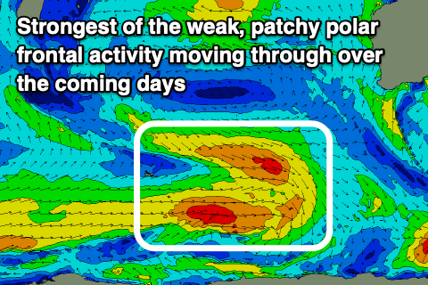
 Patchy and not overly strong polar frontal activity looks to generate an initial mid-period SW swell for Friday afternoon but more so Saturday with sets to 4-5ft across the South West, 1ft+ in Mandurah and 1ft across Perth.
Sunday only looks to ease a touch as a reinforcing pulse of swell moves in, with a secondary pulse for Monday. Size wise these look to be around 4-5ft on the sets, but more so 3-5ft on Sunday and Monday, and a better 4-5ft Tuesday.
While the swells won't be great for Perth and Mandurah, the South West will see conditions improve with a light E/SE offshore on Friday morning, fresh E/SE Saturday morning and E/NE on Sunday.
Afternoon sea breezes will be strongest through Friday and Saturday afternoons, weakest on Sunday afternoon.
Into early next week another trough will move through, shifting winds to the SE, cleaner into Tuesday and back to the E/SE with those reinforcing pulses of mid-period SW swell.
Longer term easing surf is due through the middle to end of next week with nothing too major showing until the following week. More on this Wednesday.


Comments