Easing surf ahead of a fun new swell Saturday
Western Australia Surf Forecast by Craig Brokensha (issued Monday January 24th)
Best Days: Tomorrow morning in the South West, Friday morning in the South West, Saturday morning all locations, Sunday morning in the South West
Features of the Forecast (tl;dr)
- Easing W/SW groundswell over the coming days with mod-fresh morning SE winds tomorrow, moderate SE on Wed AM
- Small, mid-period SW swell arriving late Thu, peaking Fri with morning E/SE winds
- Stronger SW groundswell Sat with fresh E/SE-SE winds in the AM, easing Sun with fresh SE winds in the AM, stronger Mon
Recap
Fun waves in the South West early Saturday with a drop in swell from Friday to 3-5ft with an offshore wind, deteriorating from mid-morning. Perth and Mandurah were clean but tiny.
Yesterday was smaller and with clean conditions across the South West again under offshore breezes.
Today our reinforcing pulse of W/SW groundswell has bumped wave heights back up to 4-6ft in the South West, though Perth and Mandurah are still tiny, under forecast expectations. Winds have a bit of south in them favouring protected spots.
This week and weekend (Jan 25 - 31)
Down, down, down. That's the trend from this afternoon through tomorrow and Wednesday but with improving conditions for the more exposed beaches in the South West. A moderate to fresh SE breeze will limit options a little tomorrow morning, stronger S/SE into the afternoon with easing sets from 3-4ft or so.
Wednesday will be small and winds moderate SE (possibly E/SE at times through the morning) before shifting back to the S-S/SW and strengthening into the afternoon.
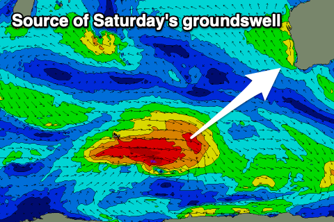
We then look at the small, mid-period SW swell dude into later Thursday and more so Friday but of greater importance is an upgrade in a trailing front in the progression which will generate a larger SW groundswell for Saturday.
 The initial, small mid-period swell will be generated by a fetch of strong W/SW winds, with gale to severe-gale winds attached to a stronger polar low behind it generating the larger swell.
Later Thursday's swell will build with sea breezes, peaking Friday to 3-5ft or so in the South West with Saturday's stronger groundswell expected to provide better 6ft to occasionally 8ft sets in the South West, 2ft sets in Mandurah and 1-2ft sets in Perth.
Winds look great with a moderate to fresh E/SE offshore ahead of sea breezes Friday, a little less favourable Saturday with E/SE-SE winds (E/NE further north).
The swell will ease into Sunday with SE-S/SE winds, strengthening through Monday from the same direction.
Longer term there are a couple of possible swell sources on the cards, both nothing overly big, but we'll have a closer look at this Wednesday.

