One more large SW swell to come, then quieter
Western Australia Surf Forecast by Craig Brokensha (issued Monday December 20th)
Best Days: Protected spots tomorrow, Wednesday morning, Thursday morning in the South West, Sunday in the South West, Monday morning in the South West
Features of the Forecast (tl;dr)
- Large SW groundswell building tomorrow afternoon with mod-fresh SE tending S/SW winds (S/SE tending SW winds further north)
- Easing SW groundswell Wed with fresh S/SE-SE tending S/SW-SW winds (lighter SE-E/SE to the north in the AM)
- Further drop in SW swell Thu with fresh S/SE-SE tending S/SW-SW winds
- Small, mid-period SW swell building Sun with fresh E/NE tending weak SW winds
- Easing SW swell Mon with strong E/NE tending NW winds
Recap
Large surf held into Saturday morning but so did the onshore winds with sloppy 8-10ft surf in the South West, 3ft in Mandurah and 2-3ft across Perth.
Yesterday was much cleaner with plenty of size still in the tank to 6ft in the South West, 2-3ft in Mandurah and 2ft across Perth.
This morning the surf is smaller but clean again with 3-5ft waves in the South West, still holding 2ft in Perth and Mandurah.
This week and weekend (Dec 21 - 26)
An onshore change has just the South West as a trough moves through and we'll see all locations improve into tomorrow as winds shift back to the SE around Margs, S/SE further north.
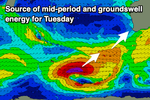
 Swell wise there should be some new mid-period SW swell in the water at dawn but we'll see our large SW groundswell building through the afternoon. The source of both these swells was a strong polar low with a pre-frontal fetch of W/NW winds ahead of it.
The largest swell energy will originate from the polar low and should reach 10ft on the sets across the South West, with surf to 6ft in the morning. Mandurah should see 3ft sets with 2-3ft waves across Perth but winds will shift S/SW-SW and be strong.
Wednesday looks best in protected spots with S/SE-SE offshore winds and easing surf from 8ft+ across the South West, 2-3ft in Mandurah and 2ft+ in Perth. Perth and Mandurah look to see lighter winds in the morning, from the SE across Mandurah and E/SE in Perth ahead of sea breezes.
Make the most of the easing swell as we'll see the size continuing to ease into the end of the week.
 Winds look to be generally S/SE-SE in the mornings, favouring protected spots ahead of afternoon sea breezes. Stronger SE tending S/SE winds are due Friday as the swell drops further, leaving limited options for a decent wave.
Saturday is a no go as the swell reaches a low point, while a small, mid-period SW swell is due to build through Sunday and peak into the evening.
The source of this is a relatively weak but elongated front generating W/NW winds east of the Heard Island region on Wednesday evening and Thursday.
This swell will favour the South West with sets to 4-5ft due, possibly reaching 1-1.5ft in Mandurah.
Hot, offshore E/NE winds are due Sunday morning, but as the swell peaks winds will shift onshore but hopefully without too much strength. Monday looks hot and clean again with strong E/NE winds and an easing swell.
Longer term there's nothing too significant on the cards into the end of the year but more on this Wednesday.

