A couple of decent days before the westerly winds kick in
Western Australia Surf Forecast by Craig Brokensha (issued Friday December 10th)
Best Days: Protected spots Sunday, Monday morning, Wednesday morning
Features of the Forecast (tl;dr)
- Large, inconsistent SW groundswell building tomorrow PM, easing Sun with SW-S/SW winds tomorrow, fresh-strong S/SE Sun
- Easing SW swell Mon with fresh morning E/SE winds and sea breezes
- Smaller surf Tue with S/SE winds
- Large SW groundswel Wed with fresh E/SE tending SW winds
- S tending SW winds on Thu, strong W/SW Fri with a large, building W/SW swell
Recap
A secondary pulse of SW groundswell yesterday with good 6ft surf in the South West and gusty offshore winds which slowly deteriorated and turned more N'ly through the day ahead of an evening change. Mandurah was a little bumpy and small to 1-2ft, tiny across Perth.
Today we've got onshore winds and poor surf across all locations with a drop in swell from yesterday.

Windy surf yesterday AM
This weekend and next week (Dec 11 - 17)
Into the weekend we've got another pulse of SW groundswell on the cards but this will be inconsistent, generated by a strong polar low that fired up south-east of South Africa on Monday, projecting W/NW-W gales through our medium-far swell window.
We should see the swell coming in a touch bigger than the swells seen this week with sets to 6-8ft across the South West magnets, 2ft in Mandurah and 1-2ft across Perth.
The swell should build tomorrow afternoon but peak early Sunday and winds look SW-S/SW across all locations tomorrow, with a slim chance of lighter winds at dawn in Perth and Mandurah but they'll be tiny.
 Sunday will become slightly better with winds shifting S/SE but being fresh to strong, so hit up protected spots. Monday morning still looks the pick with an E/SE offshore as sets ease from 4-6ft in the South West, 1-2ft across Mandurah and tiny in Perth.
A low point in swell is expected on Tuesday with a return to S/SE winds, but come Wednesday we're now looking at one more day of offshore E/SE winds before the westerly winds kick in.
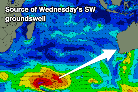
This will be timed with the arrival of a large, new SW groundswell generated by a strong polar low that's currently moving in from the south-east of South Africa.
A good fetch of gale to severe-gale W'ly winds will be generated before the low breaks down east of the Heard Island region while projecting towards us. We should see a secondary strong frontal progression firing up on its tail but this bring the onshore winds into Thursday and Friday along with an additional large swell.
Size wise Wednesday's swell should come in around the 8ft range across the South West, 2ft+ in Mandurah and 1-2ft across Perth with that offshore wind, while Thursday might see early S winds, shifting strong SW through the day and then W/NW Friday as the reinforcing swell fills in.
Unfortunately it looks like continued weak mid-latitude frontal activity will bring onshore winds next weekend, improving through Tuesday the following week along with a possible new swell. More on this Monday though. Have a great weekend!

