Slow period continues until Monday week
Western Australia Surf Forecast by Craig Brokensha (issued Friday November 12th)
Best Days: Tomorrow morning in the South West, Monday morning in the South West
Features of the Forecast (tl;dr)
- Small, easing mid-period S/SW swell tomorrow with gusty E/SE tending strong S/SE winds
- Low point Sun with fresh E/SE winds and sea breezes
- New S/SW swell later Sun, peaking Mon AM with moderate E/SE tending fresh SW winds
- Easing swell Tue with N tending NW winds
Recap
Tiny, wind affected surf yesterday with the swell reaching a low point on the coast. Today a slight increase in new S/SW swell was providing 2-3ft sets under offshore winds in the South West. Perth and Mandurah have remained tiny to flat.

Fun new swell this morning
This weekend and next week (Nov 13 - 19)
The small pulse of mid-period S/SW swell seen today is providing better 3ft+ sets now across the coast and we'll see it peak this evening before easing tomorrow. We should hopefully still see 3ft waves tomorrow morning, fading through the day. Perth and Mandurah will remain tiny to flat due to the southerly swell direction.
Conditions will be good but windy with a gusty E/SE offshore wind, stronger S/SE into the afternoon.
 Sunday looks like a lay day with the swell bottoming out along with morning offshore winds, deteriorating into the afternoon.
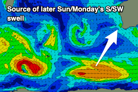
Our better pulse of mid-period S/SW swell for Monday (arriving late Sunday) is still on track, with the polar front linked to this currently moving out of our swell window, south-southwest of the state. A good fetch of strong W/NW winds were generated yesterday though and this should provide better 3-4ft waves across Margs Monday morning, easing through the day. Perth and Mandurah will unfortunately remain tiny.
Winds will be favourable and moderate from the E/SE ahead of fresh SW sea breezes, so get in for the early to mid-morning surf.
A small low forming right off our coast will bring unfavourable N'ly tending NW winds on Tuesday as the S/SW swell from Monday eases.
Longer term the blocking setup through the eastern Indian Ocean will persist next week, resulting in a run of small, average surf containing through until at least Monday the 22nd of November.
The low on Tuesday will weaken and drift to the east into the evening, leaving SE winds into Wednesday morning but with no new swell.
 Another small pulse of mid-period S/SW swell is due late week but this looks smaller than Monday's with the swell generating fetch being more NW than W/NW.
Winds aren't ideal when it arrives Thursday, better and more offshore Friday but likely only 2ft+ across Margs.
Longer term there's a bit more activity forecast south-east of South Africa and through the southern Indian Ocean, with a couple of significant storms likely to generate better groundswells from the 22nd. Winds aren't as favourable though, so we'll have another updated on this Monday. Have a great weekend!

