Slow period continues
Western Australia Surf Forecast by Craig Brokensha (issued Wednesday November 10th)
Best Days: Monday morning in the South West
Features of the Forecast (tl;dr)
- Low point in swell tomorrow with SE tending strong S/SW winds
- Small, building S/SW swell Fri with fresh E/SE tending strong S/SE winds
- Easing S/SW swell Sun with moderate E/SE tending S/SW winds
- Low point in swell Sun with E/SE tending S/SW winds
- Small, new mid-period S/SW swell Mon with E/SE tending SW winds
Recap
Windy, average waves across the South West yesterday with 3ft or so of S/SW swell, cleaner to the north but tiny.
Today the South West is cleaner but small and easing from 2-3ft while Perth and Mandurah are tiny to flat.
This week and next (Nov 11 - 19)
The small swell from the last couple of days will fade into tomorrow leaving nothing of note across the state.
Winds will be light to moderate out of the south-east ahead of strong S/SW sea breezes.
Cleaner conditions are due into Friday with an E/SE offshore wind but the swell will be small to tiny again, building into the afternoon with the arrival of a small, mid-period S/SW swell.
The source of this is a weak fetch of SW winds on the polar shelf and we'll be lucky to see 2-3ft sets across Margs later in the day, easing from a similar size Saturday morning.
With strong afternoon breezes Friday, Saturday morning will be the pick if you're desperate in the South West with offshore E/SE winds again, strong S/SE into the afternoon.
 Sunday looks average with another low point in swell but with morning offshore winds.
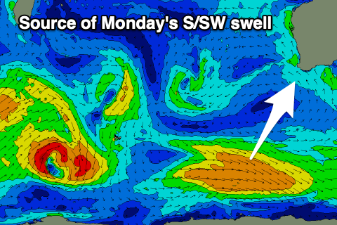
Looking at our slightly better pulse of mid-period S/SW swell for Monday, and this will be generated by a stronger and broader fetch of W/NW winds moving along the polar shelf over the coming days.
Size wise it will only favour the South West again but come in at 3ft for the most part with 4ft sets possible on the swell magnets. Winds look decent and offshore from the E/SE again but a small low forming to our west will bring less favourable S/SE winds to all locations Tuesday morning as the swell fades.
 Unfortunately a better groundswell that was on the cards for the middle of the week is off the cards now and there's nothing of greater significance due until next weekend at this stage.
A large persistent blocking pattern will be the reason behind the run of small surf, but we may see a mid-latitude low moving in from the south-east of Madagascar early next week, generating a moderate sized W/SW swell for Saturday/Sunday. ECMWF doesn't have this low and instead, a much weaker trough so we'll have a closer look at this swell and the expected conditions on Friday.

