Workable period before things go quiet
Western Australia Surf Forecast by Craig Brokensha (issued Monday November 1st)
Best Days: Perth and Mandurah Wednesday morning, early Thursday all locations, Friday protected spots, Saturday morning, early Sunday
Features of the Forecast (tl;dr)
- Easing local swell from low tomorrow with strong W/SW winds, abating later
- Building mid-period SW swell Wed with light-mod W/NW winds (light E/NE in Perth and Mandurah during the AM)
- Secondary pulse of mid-period SW swell Thu PM and Fri AM with variable winds tending onshore mid-late AM Thu, S'ly Fri (S/SE early Perth and Mandurah)
- Smaller SW swell for Sat PM with E/SE tending SW winds, easing Sun with SE tending S/SW winds (S/SE Perth and Mandurah)
Recap
Small, clean, fun surf across the South West on Saturday morning, bigger and better yesterday with a new swell and offshore winds. Perth and Mandurah failed to offer any real size with clean conditions but tiny surf.
Today a small, deepening low is pushing in across the south-west of the state bringing strengthening onshore winds and building surf from a small base this morning. Conditions are now poor but larger and messier across all locations.
This weekend and next week (Nov 2 - 7)
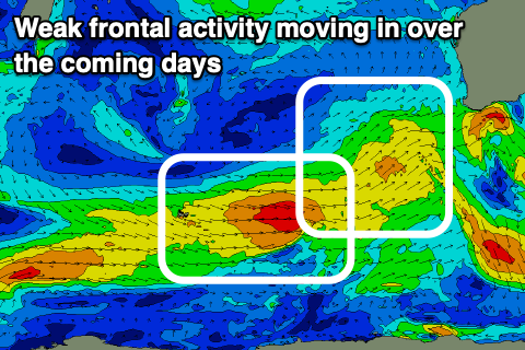
Following today's low and local increase in windswell, we'll see broader, weaker fronts pushing up and under us over the coming days, generating moderate to large pulses of mid-period swell but with poor winds. Locations north of Margs look to see periods of better winds into Wednesday but more on this below.
 With the low from today moving off to the east and weakening, we'll see the swell drop in size tomorrow across all locations but with a persistent, strong W/SW breeze, abating into the evening.
The next front approaching from the south-west will bring some building mid-period energy on Wednesday, peaking through the afternoon followed by a secondary pulse Thursday afternoon/Friday. Winds strengths in this frontal progression aren't especially strong and mostly sub-gale force, leading to moderate sized + pulses of swell.
Winds will be favourable for Perth and Mandurah Wednesday morning and light E/NE, with light to moderate W/NW winds in the South West. Size wise Perth and Mandurah look to start around 2ft with a bit more size into the afternoon but with sea breezes as the new swell fills in.
The South West should build to 5-6ft but with those onshore winds.
Thursday morning should be similar in size to Wednesday afternoon and with a period of early variable winds in the South West, S/SE further north ahead of a trough and onshore change mid-late morning.
The secondary pulse of swell for the afternoon and Friday morning looks a bit stronger with 6ft+ sets in the South West, 2-3ft waves across Mandurah and 2ft+ waves in Perth, easing later in the day and smaller Saturday morning.
 Winds on Friday look to be out of the S/SE in Perth and Mandurah again through the morning with a stronger S'ly breeze pushing through with a trough across the South West. Saturday looks much better with an E/SE offshore wind and the slightly smaller swell from Friday.
A new, mid-period SW swell is due into the afternoon Saturday, generated by the backside of the weak frontal progression, and this should keep the South West around 4-6ft but small and to 2ft across Mandurah with 1-2ft sets in Perth.
The swell will ease Sunday along with favourable morning SE winds in the South West, less favourable and from the S/SE further north in Perth and Mandurah.
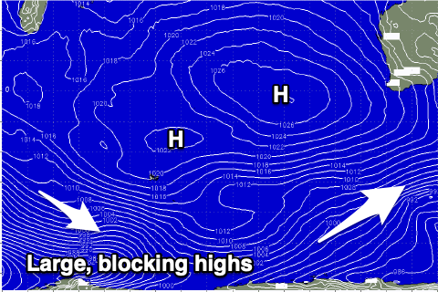
Looking longer term, the Southern Ocean looks to fall quiet with a large, dominating blocking high setting up camp west of us, so try and make the most of the coming windows of surf this period.

