A couple of good swells with workable winds
Western Australia Surf Forecast by Craig Brokensha (issued Wednesday October 6th)
Best Days: Perth and Mandurah for the keen early tomorrow, Saturday morning, Sunday, Tuesday morning Perth and Mandurah, Wednesday morning
Features of the Forecast (tl;dr)
- Small tomorrow with strengthening NW tending W/NW winds (E/NE-NE early in Perth and Mandurah)
- Mod-large mid-period SW swell building late Fri, peaking Sat AM with mod-fresh S/SE tending S/SW winds
- Easing SW swell Sun with mod-fresh E/NE winds ahead of sea breezes
- Large SW groundswell for Tue with S/SW winds in the South West, SE further north
- Easing SW swell Wed with E tending NW winds
Recap
Perth offered the best waves yesterday with peaky 2-3ft sets under light winds, bumpy around Mandurah and not ideal, average across the South West.
Today is much better with clean conditions across all locations and 4-5ft sets in the South West, 2-3ft across Mandurah and 2ft in Perth.
This week and weekend (Oct 7 - 10)
The next frontal system is on the approach and this will bring strengthening NW tending W/NW winds tomorrow, though Perth and Mandurah should see early E/NE-NE breezes. The swell will be at a low point with small waves on the beaches for the keen in Mandurah and Perth.
We'll see a S/SW change moving through into early Friday morning with fresh SW tending S/SW winds, S/SE early in Perth and Mandurah. Some small, mid-period swell should be in the water but into the afternoon our better groundswell is due to fill in.
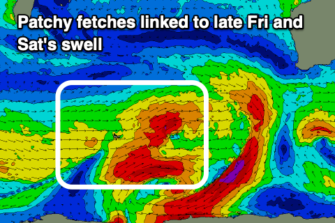
 The source of this swell was dual polar lows firing up around the Heard Island region, resulting in patchy fetches of W/SW gales being projected through our swell window. The progression is still strong south-west of us but will weaken while edging closer, leaving the swell to build later Friday but peak Saturday morning.
Size wise the South West should see good 8ft sets with 3ft waves in Mandurah and 2-3ft across Perth, easing steadily through the day.
Local winds are the issue, with S/SE breezes due across most locations Saturday morning (tending SE at times) ahead of S/SW sea breezes, with Sunday coming in cleaner with a moderate to fresh E/NE offshore ahead of moderate, workable sea breezes. The swell will be on the ease, likely from the 5-6ft range in the South West, 2ft+ in Mandurah and 2ft across Perth.
 We then look at the cold outbreak arriving through next week, with a strong cold front due to spawn off a polar low and project into us on Monday.
This will bring strengthening W/NW tending SW winds Monday, with the front clearing off quickly to the east Tuesday as a large SW groundswell fills in. Unfortunately it looks like we'll see S/SW winds lingering in the South West, with better SE offshores to the north and a swell in the 8-10ft range, 3ft+ in Mandurah and 3ft across Perth.
Wednesday looks cleaner as the swell eases, but we'll have a closer look at this on Friday.

