Onshore winds and weather set in
Western Australia Surf Forecast by Craig Brokensha (issued Wednesday September 29th)
Best Days: Keen surfers tomorrow morning in selected spots, possibly Perth and Mandurah Tuesday, Wednesday morning
Features of the Forecast (tl;dr)
- Inconsistent SW groundswell and much smaller NW windswell tomorrow. Moderate N/NW winds, freshening during the day (moderate N/NE early in Perth and Mandurah)
- Swell easing Fri with strong NW tending W/SW winds
- Large, building mid-period W/SW swell Sat with W/SW tending strong W/NW winds
- Easing surf Sun with strong SW winds, abating and swinging W
- Building W/SW groundswell Mon PM with fresh W/NW winds, peaking Tue with strong S winds (variable Perth and Mandurah early)
- Easing swell Wed with morning E/SE-SE winds
Recap
Great conditions and fun surf across the South West all day yesterday with glassy 4ft sets on the swell magnets, clean also to the north but tiny.
Today, conditions aren't quite as clean but the swell is similar in size, best at spots out of the NE wind in the South West and tiny to the north.

Pure glass yesterday
This week and weekend (Sep 30 – Oct 3)
Looking at tomorrow and we should see a strong, inconsistent SW groundswell filling in across all locations and there'll be workable winds for the keen. The South West now looks to see moderate N/NW breezes, freshening through the day along with sets to 5-6ft, while Perth and Mandurah should offer 1-2ft sets with a N/NE morning breeze. The source of this swell was a strong but slightly funky structred polar low firing up west of the Heard Island region on the weekend.
While not ideal it's worth making the most of this window of workable surf as onshore winds will really set in from Friday and persist until the end of next week.
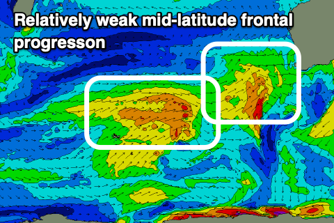
The reason for the run of onshore winds is a persistent progression of mid-latitude storms in the way of troughs/fronts and lows, but without any of them being overly strong, hence not bringing any proper size to them like the storms seen in winter.
 They'll bring plenty of moisture though and the first is due to move in Friday, bringing strong NW tending W/SW winds as it pushes through during the day, bringing some weak mid-period swell with it but mostly for Saturday.
Winds will persist from the W/SW and be strong on Saturday, tending W/NW into the afternoon and becoming stronger as the next front approaches. This will also be with larger, building levels of mid-period W/SW swell. The South West should kick to 6-8ft with 3ft waves in Mandurah and 2-3ft surf developing in Perth.
Sunday should ease from a similar size but with strong SW winds in the wake of the front, abating through the day and then tending more W'ly.
The next front in this procession will tip winds back to the W/NW on Monday while also bringing some stronger, groundswell for the afternoon, peaking Tuesday. The size looks to be more around 8ft+ across the South West, 3ft+ in Mandurah and 3ft across Perth but with strong S'ly winds moving in following the front. Perth and Mandurah may see variable winds early, but we'll confirm this Friday.
Wednesday looks to offer a better chance of E/SE-SE winds across all locations with the swell from Tuesday easing back from 6ft+ in Margs, 2-3ft in Perth and Mandurah. Late in the week a new, large, mid-period W/SW swell is on the cards but winds still look a little suss as a weak front clips the state.
We may see favourable winds Friday morning but we'll have a closer look at this in the coming updates.

