Wet, onshore period ahead
Western Australia Surf Forecast by Craig Brokensha (issued Monday September 27th)
Best Days: Tomorrow in the South West, early Wednesday selected spots in the South West, Perth and Mandurah for the keen early Thursday selected spots
Features of the Forecast (tl;dr)
- Small mid-period SW swell for tomorrow, followed by a secondary pulse for the late PM, peaking Wed
- Moderate to fresh E-E/NE tending variable winds tomorrow, strong NE tending N/NE and then NW on Wed
- Inconsistent SW groundswell and NW windswell for Thu with fresh NW winds (lighter and N'ly early in Perth and Mandurah), easing a touch Fri with strengthening N/NW winds ahead of a W change
- Mix of large swells Sat with strong W/SW winds, easing Sun with similar winds likely
- Plenty of onshore winds and swell next week
Recap
Friday's kick in swell eased back into Saturday but cleaned right up with fun waves across all regions, easing from 4-5ft in the South West, 2ft in Mandurah and 1-2ft across Perth.
Sunday was a bit smaller but clean again and fun across the swell magnets in the South West along with Mandurah.
Today a mid-latitude low has moved in bringing less favourable winds along with a weak, mid-period S/SW swell.
This week and weekend (Sep 28 – Oct 3)
As touched on last week, the coming period isn't too flash regarding quality surf or weather.
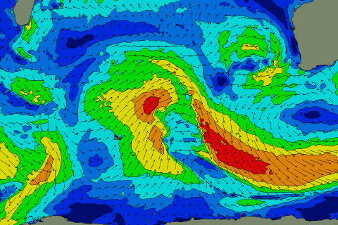
 We'll see mid-latitude lows (pictured right) bringing moisture and onshore winds with no real considerable size across the state until the weekend and early next week.
Tomorrow, the mid-latitude low linked to today's strengthening S'ly winds across the South West will push slowly east, swinging winds back offshore from the E-E/NE, variable through the afternoon.
Swell wise, a small, mid-period SW swell is due this afternoon, easing back tomorrow from 3-4ft across the magnets, tiny to the north.
Another, small mid-period SW swell is due late afternoon and more so Wednesday, generated by a distant storm south-east of South Africa late last week, therefore it'll be inconsistent and slow.
Sets look to be a touch stronger than tomorrow and to 3-4ft+ but winds will strengthen from the NE, tending N/NE ahead of a NW change as a secondary mid-latitude low that's currently west of us starts to move in.
This will bring an increase in W/NW-NW windswell across all regions on Thursday along with a new, long-period SW groundswell. Winds will remain fresh from the NW though, creating poor conditions, though Perth and Mandurah will likely see a period of lighter N'ly winds at dawn.
The groundswell has been generated by a strong but south-east tracking polar low, west of the Heard Island region on the weekend and should come in at 5-6ft across the South West and 1-2ft further north.
The swell will ease Friday as winds start to strengthen from the N/NW again ahead of yet another mid-latitude low, with a strong W'ly change pushing through the afternoon.
The earlier stages of this low will generate some moderate to large W/SW groundswell with mid-period/windswelly stuff as the low pushes in. It's all academic though with the onshore winds remaining strong from the W/SW. The South West looks 6ft+ with 2-3ft waves in Mandurah and Perth.
More onshore winds and similar amounts of swell are due Sunday with no let up to the mid-latitude activity due through next week.
Therefore picking the windows will be tricky as there aren't many. Check back here Wednesday and Friday for any change to the weekend's outlook, mainly Sunday as we slide between systems.


Comments
Glass!