Slower period with tricky winds
Western Australia Surf Forecast by Craig Brokensha (issued Wednesday September 22nd)
Best Days: Today in the South West, semi-protected spots tomorrow morning in the South West, Friday morning, Saturday
Features of the Forecast (tl;dr)
- Small mix of swells tomorrow with dawn SE winds, tending S/SE shortly thereafter and strengthening into the PM
- Inconsistent W/SW groundswell and mid-period SW swell Fri with mod-fresh E/SE tending strong S/SE winds
- Easing mix of swells Sat with fresh E/SE tending SE winds
- Smaller Sun with strengthening SW winds
- Weak, bulding S/SW windswell Mon PM with fresh SW winds, easing Tue with fresh NE tending NW winds
- Inconsistent SW groundswell building late Wed PM, peaking Thu AM with strong NW winds
Recap
Monday's S/SW groundswell eased back in size yesterday, with exposed spots still coming in at 4ft or so, 1-2ft in Mandurah and 1-1.5ft across Perth. Strong E/NE winds eased and shifted more north through the day, while this morning we've got light offshore winds and clean conditions across all regions. The swell is smaller and back to 3ft to occasionally 4ft or so in the South West, tiny and to 1-1.5ft in Mandurah with 1ft waves across Perth.

Glassy conditions and some new swell showing in the South West
This week and next (Sep 23 – Oct 1)
Into this afternoon, a small, inconsistent SW groundswell is due, generated by that flukey pre-frontal fetch of gales, providing 3-5ft waves across Margs, with tiny surf continuing across Perth and Mandurah. It looks like this is already showing as shown in the surfcam grab above.
Afternoon sea breezes will create bumpy conditions though so get in soon. This swell should hold into tomorrow morning with early favourable SE tending S/SE winds, strengthening through the day as a high moving in from the west is squeezed by a developing low to its south-east.
Margs should see surf in the 3-5ft range as Perth and Mandurah maintain 1ft.
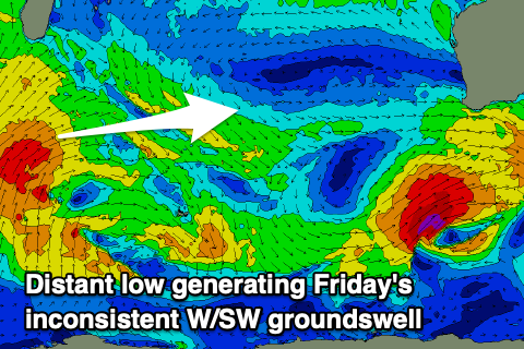
 Friday looks better with the inconsistent W/SW groundswell from south of Madagascar due to fill in. While being generated in our far swell window, the swell producing front continued to project towards us through the weekend but in a weaker form, but helping to reduce swell decay.
Open beaches should see infrequent 5-6ft sets, with 1-2ft sets across Perth and Mandurah along with more favourable E/SE offshores, shifting S/SE through the afternoon and strengthening.
Similar winds are due on Saturday as the swell starts to ease, though winds into the afternoon don't look as strong and could hold from the SE.
Come Sunday, winds look to deteriorate as a trough come mid-latitude low pushes in from the south-southwest, bringing strengthening SW winds to all locations as the swell drops further.
This low looks relatively weak and poorly structured with it kicking up a weak S/SW windswell later Monday, easing Tuesday along with SW winds on the former, and fresh NE tending NW winds on the later as a secondary mid-latitude low pushes in from the west. The South West should ease from 4ft or so on Tuesday morning, tiny to the north.
 Looking at the secondary low, and this looks poorly structured for swell generation as well, but more importantly it'll spoil some inconsistent SW groundswell energy due mid-late week.
The long-period energy will be generated by a strong polar low developing west of the Heard Island region Friday evening, with less than favourably aligned severe-gale to storm-force N/NW winds followed by a post-frontal fetch of similar strengthen W'ly winds, quickly moving south-east over the polar shelf and out of our swell window (right).
This isn't great for size and as a result, we're only due to see 6ft+ surf across the South West on Thursday morning, 2ft in Mandurah and 1-2ft across Perth, if that. Winds are still tricky as the models diverge regarding the movement of the secondary mid-latitude low but it looks like we're going to see onshore NW winds as it pushes in. More on this, which is likely to change a little, on Friday.

