Developing onshore winds and building surf
Western Australia Surf Forecast by Craig Brokensha (issued Monday September 13th)
Best Days: Today, tomorrow morning, early Wednesday Perth and Mandurah for the keen, Sunday morning Perth and Mandurah, Monday week
Features of the Forecast (tl;dr)
- Moderate + sized mid-period swell for later today, persisting tomorrow and Wed AM
- Light E/NE tending N and then N/NW winds tomorrow, stronger N/NW on Wed (N/NE-NE early in Perth and Mandurah)
- Large W/SW groundswell for Thu, with an additional, building close-range swell with strong W/SW-W winds
- Large mix of easing swells Fri with strong W/SW tending W winds
- Easing mix of swells Sat with slowly abating W/SW winds
- Reinforcing mid-period W/SW swell Sun with light E/NE-NE winds in Perth and Mandurah, moderate S/SW in the South West
- Easing surf Mon with variable offshore winds ahead of sea breezes
Recap
Building surf with cross-shore winds and good options in protected spots across the South West Saturday, lumpy and to 2-3ft in Mandurah with peaky 2ft waves in Perth.
Yesterday's was pumping with a reinforcing, large S/SW groundswell and offshore winds, coming in at 8ft+ across the South West, 3ft in Mandurah and 2-3ft across Perth. The swell eased through the day and this morning we've got smaller surf again, but great conditions. All locations are fun but watch out for sea breezes this afternoon.
This week and weekend (Sep 14 – 19)
After the last couple of days of great waves, we've got one more morning of clean conditions before onshore winds kick in from Wednesday, lasting through until next week.
Firstly, an inconsistent pulse of SW groundswell is due later today, with it peaking tomorrow, providing 5-6ft+ waves across Margs, 2ft sets in Mandurah and 1-2ft waves in Perth. This swell and a similar size, reinforcing pulse for the afternoon and Wednesday morning have been generated by a flurry of frontal systems projecting towards us over the weekend from the Heard Island region.
Winds will be favourable and light E/NE tomorrow morning, shifting more N'ly through the day and then N/NW into the afternoon across the South West, S/SW further north. Therefore surf in the morning for the best waves and conditions.
 An approaching mid-latitude frontal system will bring strong N/NW winds on Wednesday which will be N/NE-NE early in Perth and Mandurah. This will be with similar amounts of swell to Wednesday owing to that reinforcing pulse.
Of greater significance is a large W/SW groundswell that's due to fill in Thursday, though spoilt locally by the mid-latitude front, which will then form into a low and stall across us into the end of the week.
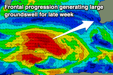
The large groundswell will be generated by a stronger polar frontal progression that's currently around the Heard Island region. A fetch of severe-gale W/NW-W winds are being generated, with the swell due to fill in Thursday and peak around 8-10ft in the South West, 2-3ft in Mandurah and Perth.
 Some localised stormy swell will build on top of this energy though, owing to strong to gale-force W/SW winds being projected into us during the day. Expect stormy sets to go larger into the afternoon along with strong W-W/SW winds.
Unfortunately, the slow, moving nature of the low and a secondary weak front moving in on the weekend will see winds remain onshore through Friday and Saturday, improving across Perth and Mandurah into Sunday morning.
Size wise the groundswell and localised windswell will ease into Friday but with strong W/SW tending W winds as the next weak front approaches. Winds will hold from the W/SW on Saturday but slowly ease in strength as the front starts to pass but with no new swell.
Come Sunday when winds tend lighter S/SW in the South West and variable E/NE-NE across Perth and Mandurah, the surf will be smaller but some reinforcing mid-period swell is due to be in the water.
 This will be generated by the earlier stages of the weak front moving in through the weekend and should keep the South West around 6ft to maybe 8ft, 2ft+ in Mandurah and 2ft across Perth.
Monday will become cleaner across all locations with a light, variable offshore wind but easing surf from Sunday.
Longer term, a strengthening polar frontal progression south-west of us early next week should bring some good swell for later next week but with what looks to be at this stage, average winds for the South West, cleaner to the north. More on this in the next few updates though.

