More windows opening up with large swells
Western Australia Surf Forecast by Craig Brokensha (issued Wednesday September 8th)
Best Days: Margs tomorrow, Perth and Mandurah from late morning, Perth and Mandurah Friday morning, protected spots Saturday, Sunday morning, Monday morning
Features of the Forecast (tl;dr)
- Large W/SW groundswell peaking tomrorow AM, easing with light E tending E/NE winds ahead of W/NW sea breezes in the South West, strong S/SE winds further north, easing and tending E/SE into the early afternoon
- Easing W/SW swell Fri with strengthening W winds (variable offshore early in Perth and Mandurah)
- Large SW groundswell building Sat with strong S/SE winds (possibly SE for a period in Perth and Mandurah)
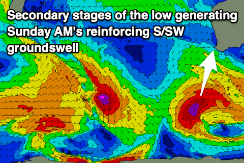
- Large, reinforcing S/SW groundswell Sun AM, easing with morning offshore winds ahead of sea breezes, similar Mon as the swell eases
Recap
Easing surf over the past couple of days with less than favourable winds from the northern quadrant. Early in the South West was OK yesterday, similar in Perth and Mandurah, less so today.
The mid-latitude low linked to these winds should bring some large, new W/SW groundswell later today, peaking tomorrow morning as discussed below.
This week and weekend (Sep 7 – 12)
A trough is currently moving through the South West, bringing lighter onshore winds and the large W/SW groundswell has started to build with 5-6ft sets showing on the reefs. This swell which is expected to peak tomorrow morning was generated by a strong, slow moving and slightly off axis mid-latitude low that fired up in the southern Indian Ocean on the weekend.
A mixed fetch of gale to severe-gale winds were projected in our swell window, with a couple of storm-force barbs, with the swell due to ease back from the 10ft range on the sets tomorrow morning (if not for the odd bigger cleanup), 3ft+ in Mandurah and 3ft across Perth.
Winds will improve in the wake of today's trough in the South West but still be changing around dawn to the north. We're due to see light E tending E/NE winds in the South West with variable W sea breezes, while to the north stronger, less favourable S/SE winds are due at dawn, easing through the day and swinging more E/SE through the early afternoon. So while bumpy early early it'll improve through the day.
Make the most of this window in the South West as winds will switch back onshore from the W Friday, while Perth and Mandurah will see light E/SE offshore winds before shifting W/SW around midday and strengthening.
 This change will be associated with a strong polar low pushing in from the east from the Heard Island region today before projecting north-east up and towards South Australia.
The low will produce an initial fetch of W/SW gales which looked to strengthen to the severe-gale to storm-force range while moving more through our southern swell window on Friday.
This will see a mix of SW and S/SW groundswell for the weekend, with the first arriving Saturday, followed by the second Sunday.
Saturday's swell should build through the day, reaching 6-8ft across the South West, 2-3ft in Mandurah and 2ft across Perth into the afternoon. The secondary S/SW groundswell looks to favour the South West and will keep 8ft sets hitting the magnets Sunday morning (possibly showing late Saturday), easing into the afternoon with 2ft to possibly 3ft sets in Mandurah, 2ft in Perth.
 Winds won't be ideal Saturday and strong from the S/SE across all locations (possibly tending SE for periods in Perth and Mandurah through the morning), much better Sunday and E/NE across the South West, E further north ahead of sea breezes. Monday will be clean again as the swell eases further.
Longer term, a significant polar frontal progression is due to fire up south-west of us later in the weekend and through early next week generating an oversized, long-period SW groundswell late next week. Ahead of this some mid-period energy is due but with onshore winds. More on this in Friday's update though.

