Further increase in swell and wind this period, improving from late week
Western Australia Surf Forecast by Craig Brokensha (issued Monday August 30th)
Best Days: Friday morning Perth and Mandurah, possibly protected spots in the South West, Saturday and Sunday all locations
Features of the Forecast (tl;dr)
- Large, mid-period SW swell for tomorrow AM with mod-fresh W/SW-W winds in the South West, strengthening from the NW into the PM. Possible variable winds in Perth and Mandurah but not clean
- Large SW groundswell arriving late tomorrow, peaking Wed with strong W/NW winds
- Oversized SW swell Thu with strong SW winds
- Easing SW groundswell Fri with moderate S/SW tending W/SW winds in the South West, NE tending W/NW in Perth and Mandurah
- Easing SW swell Sat with variable morning winds in the South West, E/NE further north
- Large SW groundswell building Sun with E tending variable winds
Recap
Large, onshore surf across the Margaret River region Saturday, with cleaner, peaky conditions to the north and 3ft sets in Mandurah, 2-3ft across Perth. Yesterday was smaller and onshore across all locations as the start of a strong frontal progression pushed up and into us.
Today the surf is on the build with strong onshore winds and poor conditions from the South West to Perth.
This week and weekend (Aug 31 – Sep 5)
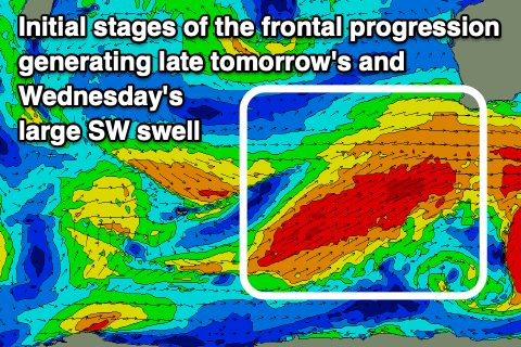
Currently a strong, drawn out frontal progression is pushing across the south of the state, bringing building swell, onshore winds and poor surfing conditions.
 The strongest winds contained in the current setup are moving through our swell window today, with this swell due to arrive later tomorrow and peak Wednesday morning.
Ahead of this though, large, mid-period energy is due to fill in tomorrow, coming in at an easy 10ft across the South West, 3ft+ in Mandurah and 3ft across Perth on the sets. The stronger groundswell due later in the day is still expected to reach 10-12ft across the South West, 3-4ft in Mandurah and 3ft across Perth, similar in size Wednesday morning.
Locally winds look better tomorrow across Perth and Mandurah, variable but possible light out of the W. Even if light E, with W winds out to sea, conditions will still be lumpy and bumpy tomorrow. Not ideal. The South West should see moderate to fresh W/SW-W winds, strengthening from the NW into the afternoon.
 Come Wednesday strong W/NW winds are due across all locations as we see the secondary, vigorous polar frontal system pushing up and towards us. With severe-gale, pre-frontal W/NW winds initially aimed in our swell window tomorrow, followed by post-frontal strong to gale-force SW winds pushing up and into us Thursday, a secondary pulse of oversized SW swell is due into Thursday.
The South West looks to come in at 12ft+ with 3-5ft waves in Mandurah and 3-4ft surf in Perth but with strong SW winds.
Friday is looking cleaner across Perth and Mandurah with morning NE winds and light sea breezes, though Margs will still be average with a moderate S/SW tending W/SW breeze.
The surf looks to remain large, but easing with 10ft sets across the South West, 3ft in Mandurah and Perth, becoming smaller through the day.
 The models diverge slightly regarding a small trailing front following all this activity, but it looks to be on the weaker side, resulting in light winds developing across all locations Saturday morning. It may be variable from the NE in the South West and E/NE further north, with Friday's swell continuing to ease in size and power.
Come Sunday, light E'ly offshore winds are guaranteed, along with a strong, new SW groundswell building through the day. The source of this swell is strengthening polar low east of the Heard Island region, generating what at this stage looks to be 6-8ft surf across the South West, with smaller waves to the north. More on this in the coming updates though.

