Windy, building swells with limited options for a clean wave
Western Australia Surf Forecast by Craig Brokensha (issued Wednesday August 25th)
Best Days: Protected spots for the keen in Perth and Mandurah Friday morning, Saturday
Features of the Forecast (tl;dr)
- Strong W tending SW winds tomorrow with building surf
- Large, mid-period W/SW swell Fri with strong S/SW winds (possibly S-S/SE for a period in Perth and Mandurah through the morning)
- Inconsistent, large W/SW groundswell for Sat AM, easing. Variable S winds tending W/NW in the South West, light E/NE tending NW further north
- Small surf Sun with strengthening W/NW-W winds in the South West, NE tending NW further north
- Large, building mid-period SW swell Mon with strong W winds
- Large SW groundswell Tue with strong W tending NW winds
- Reinforcing large SW swell Wed with strong NW tending SW winds
Recap
The South West was nice and clean most of yesterday with strong offshore winds and a drop in size from Monday, coming in at 4-6ft. Mandurah was a clean 2ft+ and Perth 1-2ft.
This morning conditions were a little less favourable with a drop in size across Perth and Mandurah to the tiny range. The South West is seeing a new, inconsistent SW groundswell and surf to 4-5ft. There should be the odd bigger one through the day but winds will go more N'ly.
This week and weekend (Aug 26 - 29)
I hope you made the most of the last few days of clean conditions as we've got a run of onshore winds to end off the week.
A small, mid-latitude front pushing in from the west will bring strong W tending SW winds to the South West tomorrow, similar to the north and some building windswell and mid-period swell through the afternoon.
 The mid-period energy will fill peak Friday, with a stronger groundswell pulse for Saturday, all generated by the same frontal progression.
This progression is currently around the Heard Island region, generating a fetch of weakening gale to severe-gale W/SW winds, which will be strong once the front moves in tomorrow afternoon.
Size wise, the mid-period energy should come in at 8ft+ across the South West Friday, 3ft or so in Mandurah and 2-3ft in Perth.
Winds will remain strong from the S/SW on Friday, with Perth and Mandurah likely to see a period of S-S/SE winds, though conditions will still be bumpy and best in protected spots.
Come Saturday morning the groundswell from the earlier and strongest stage of the frontal progression will move in, keeping the South West up around 8ft on the sets, 3ft but less consistent in Mandurah and 2ft+ in Perth.
Winds will improve considerably Saturday morning and tend E/NE across Perth and Mandurah through the morning, more variable from the S'th in the South West. Afternoon sea breezes look relatively weak and workable into the afternoon.
 As we move into Sunday an approaching trough ahead of a stronger polar frontal progression will bring strong W-W/NW winds to the South West and early NE winds to Perth and Mandurah. We'll be in between swells though with smaller 2ft and 1-2ft leftovers due respectively.
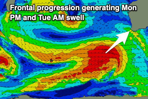
Looking at the frontal progression and it's changed up a bit from Monday with it coming in not as strong but paving the way for secondary strong cold outbreak behind it which will push high into the Indian Ocean, west of us. This isn't ideal for winds with a large swell due from the initial frontal progression pushing up towards us Saturday and Sunday, filling in Tuesday. Winds will remain strong from the W though, and W tending NW on Tuesday creating poor conditions.
The South West should see 10ft+ surf with 3ft+ waves in Mandurah, 2-3ft across Perth later Monday and into Tuesday morning.
 A secondary, large reinforcing SW groundswell is due Wednesday from pre-frontal gales moving in ahead of the the big northward projecting front, bringing larger surf Wednesday. Winds will remain poor though and NW tending SW as the front pushes through, holding from the SW Thursday as the swell remains large.
Unfortunately there doesn't look to be any improvement to the outlook into the end of the week as frontal systems continue to impact the state but more on this in the coming updates.

